A collection of Spain Maps; View a variety of Spain physical, political, administrative, relief map, Spain satellite image, higly detalied maps, blank map, Spain world and earth map, Spain’s regions, topography, cities, road, direction maps and atlas.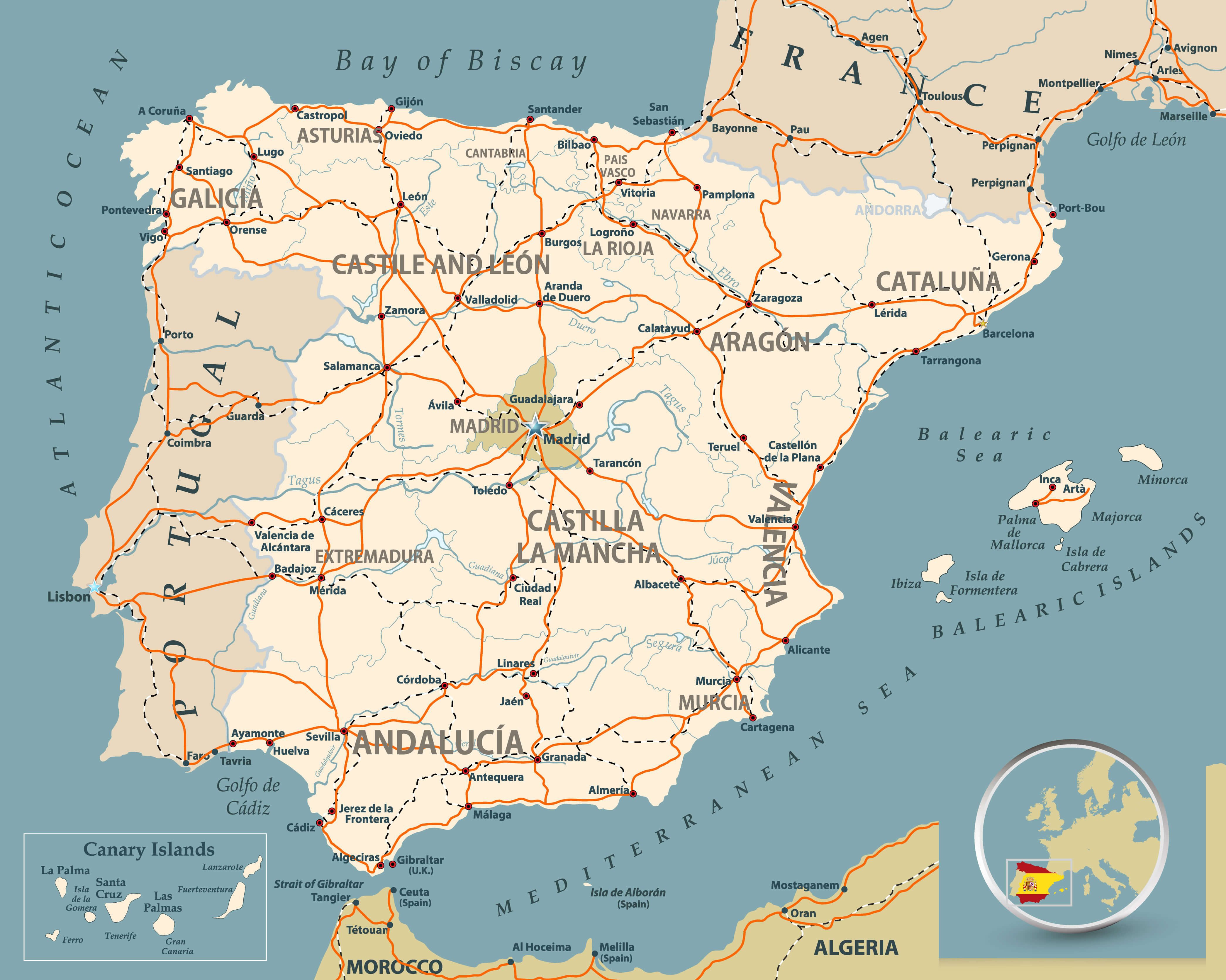 Road map of Spain with highways, railroads, cities, rivers and navigation icons/Road map of Spain.
Spain Satellite Map with Portugal
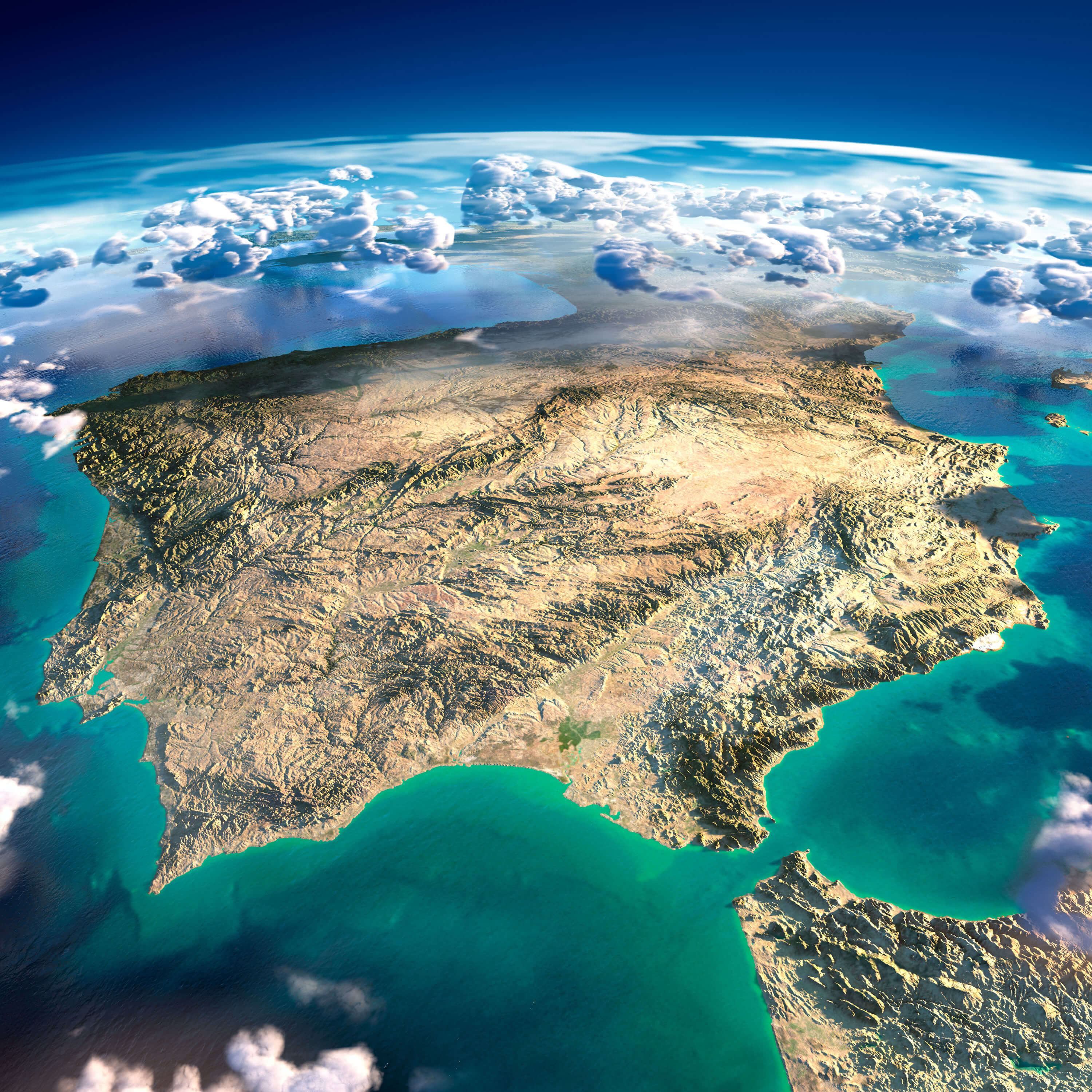
Highly detailed Spain and Portugal Satellite Map, Earth with exaggerated relief, translucent ocean and clouds, illuminated by the morning sun.
Brief information about Spain
Spain, located on the Iberian Peninsula in southwestern Europe, is renowned for its rich history, diverse culture and beautiful landscapes. With a heritage influenced by the Romans, Visigoths and Moors, Spain is home to a remarkable blend of architecture, cuisine and traditions. It has 17 autonomous communities, including Catalonia, Andalusia and the Basque Country, each with a unique cultural identity. Spain’s capital, Madrid, is a vibrant city celebrated for its art museums and historical landmarks, while Barcelona, another major city, is famous for Antoni Gaudí’s modernist architecture and Mediterranean beaches.
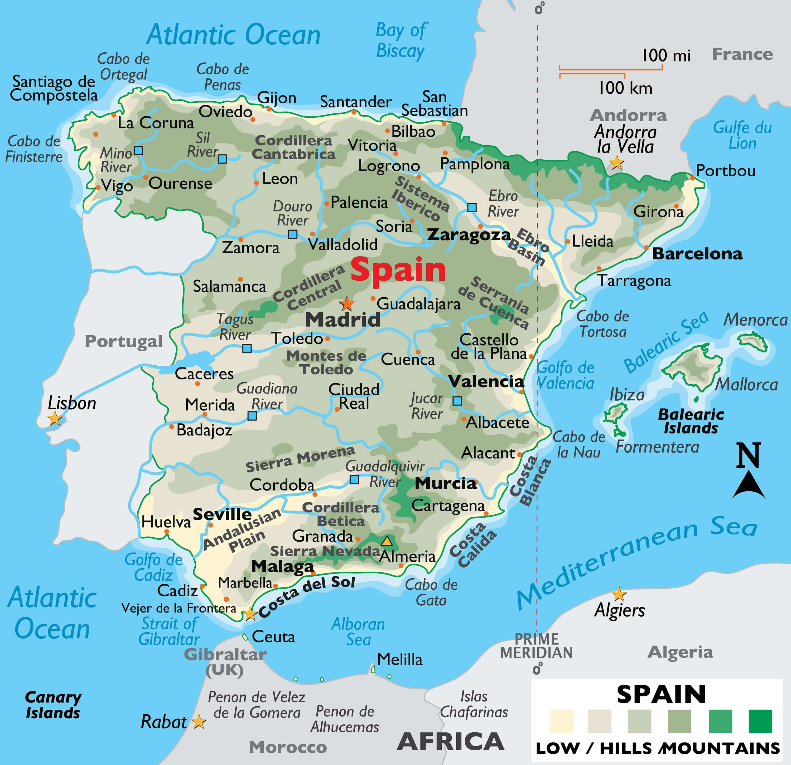
Spain map with major cities and rivers: Madrid, Barcelona, Ebro, Guadalquivir.
Severe Flooding in Eastern Spain (Valencia and Murcia) – October 30, 2024
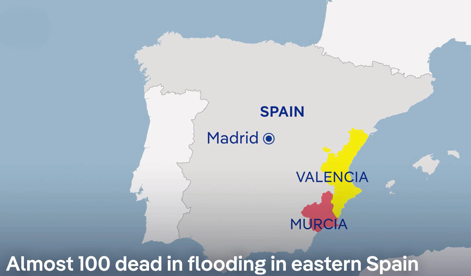
Map showing flooding in Valencia and Murcia, eastern Spain, October 30, 2024.
This map shows the regions of Valencia and Murcia in eastern Spain, where severe flooding has tragically claimed nearly 100 lives as of 30 October 2024. The map shows Valencia in yellow and Murcia in red, indicating the severely affected areas. Unusually heavy rainfall has led to catastrophic flooding, affecting communities, infrastructure and emergency services. The proximity of these regions to the Mediterranean Sea, combined with recent weather patterns, has contributed to the extent of the flooding. This event highlights the severe impact of extreme weather on the east coast of Spain.
Rainfall Distribution in Spain (October 2024)
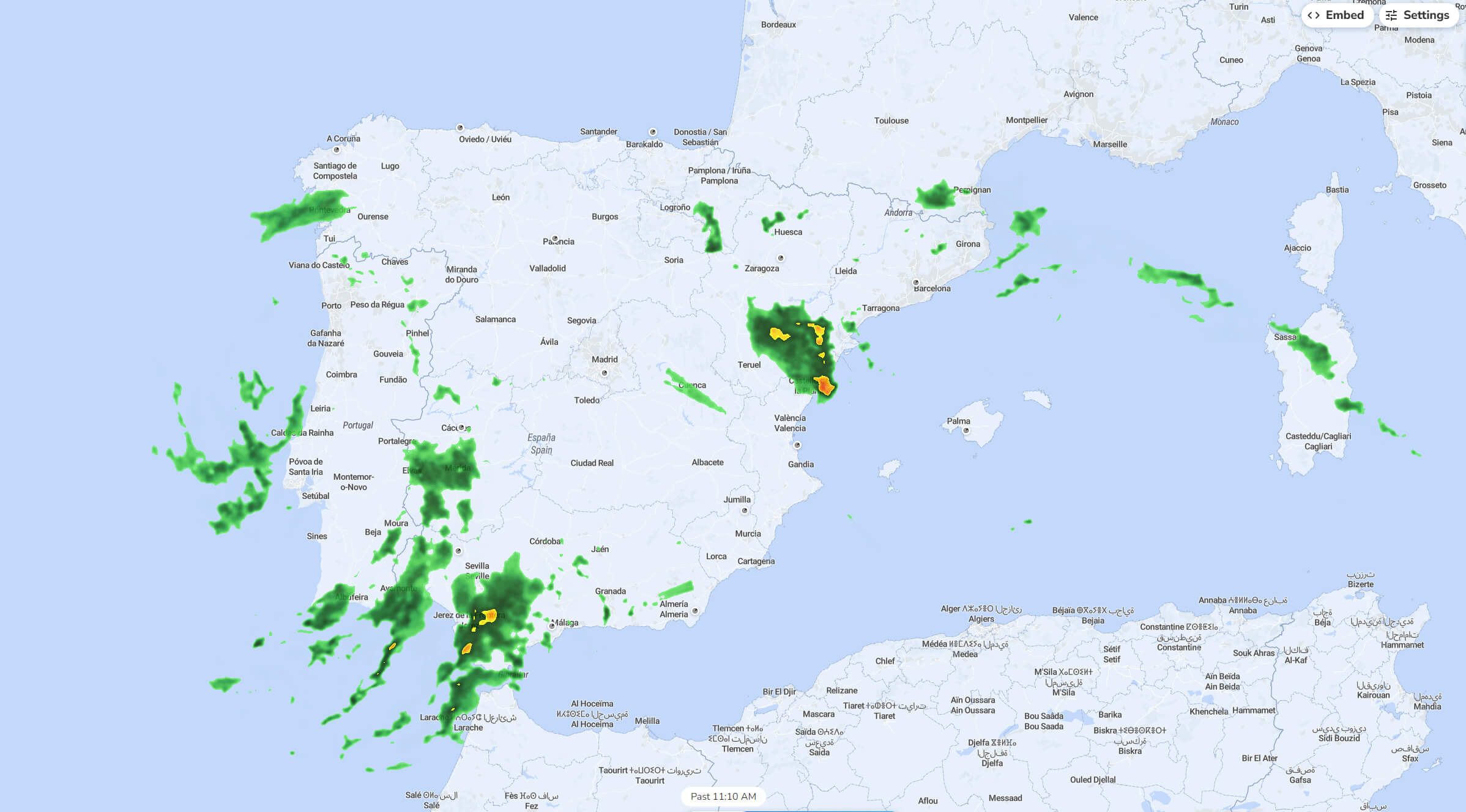
Rainfall map of Spain in October 2024, showing precipitation areas.
This rainfall map of Spain from October 2024 shows areas of precipitation across the country. Dark green areas indicate moderate rainfall, while yellow areas indicate heavier rainfall. The heaviest rainfall is concentrated in the southeastern region around Valencia and in the southern parts near Seville. Other areas, such as Galicia in the north-west and parts of the north coast near the Pyrenees, will also see rain. Some lighter, scattered showers are present in central Spain, while the eastern Mediterranean coast and parts of the Balearic Islands show minimal precipitation. This map reflects Spain’s varied autumn weather, with coastal and mountainous regions receiving more rain than inland areas.
Spain Satellite Rainfall and Weather Map (October 30, 2024)
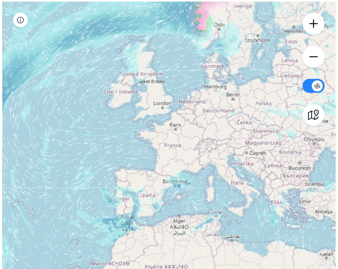
Satellite map of Spain’s rainfall and wind patterns on October 30, 2024.
This satellite weather map from 30 October 2024 shows rainfall and wind patterns affecting Spain and surrounding areas in Europe. Heavy rainfall is seen over parts of Ireland, the UK and Norway, while lighter precipitation is seen over parts of western France and the northern coast of Spain. Wind flow lines over the Atlantic indicate a strong circulation, pushing rain-bearing clouds towards the European mainland and influencing the weather over Spain and its neighbours. Spain itself experiences light rainfall along its northern coast, while the central and southern regions appear mostly dry. This map shows the movement of Atlantic weather fronts affecting European weather on this particular day.
Elevation Map of Spain
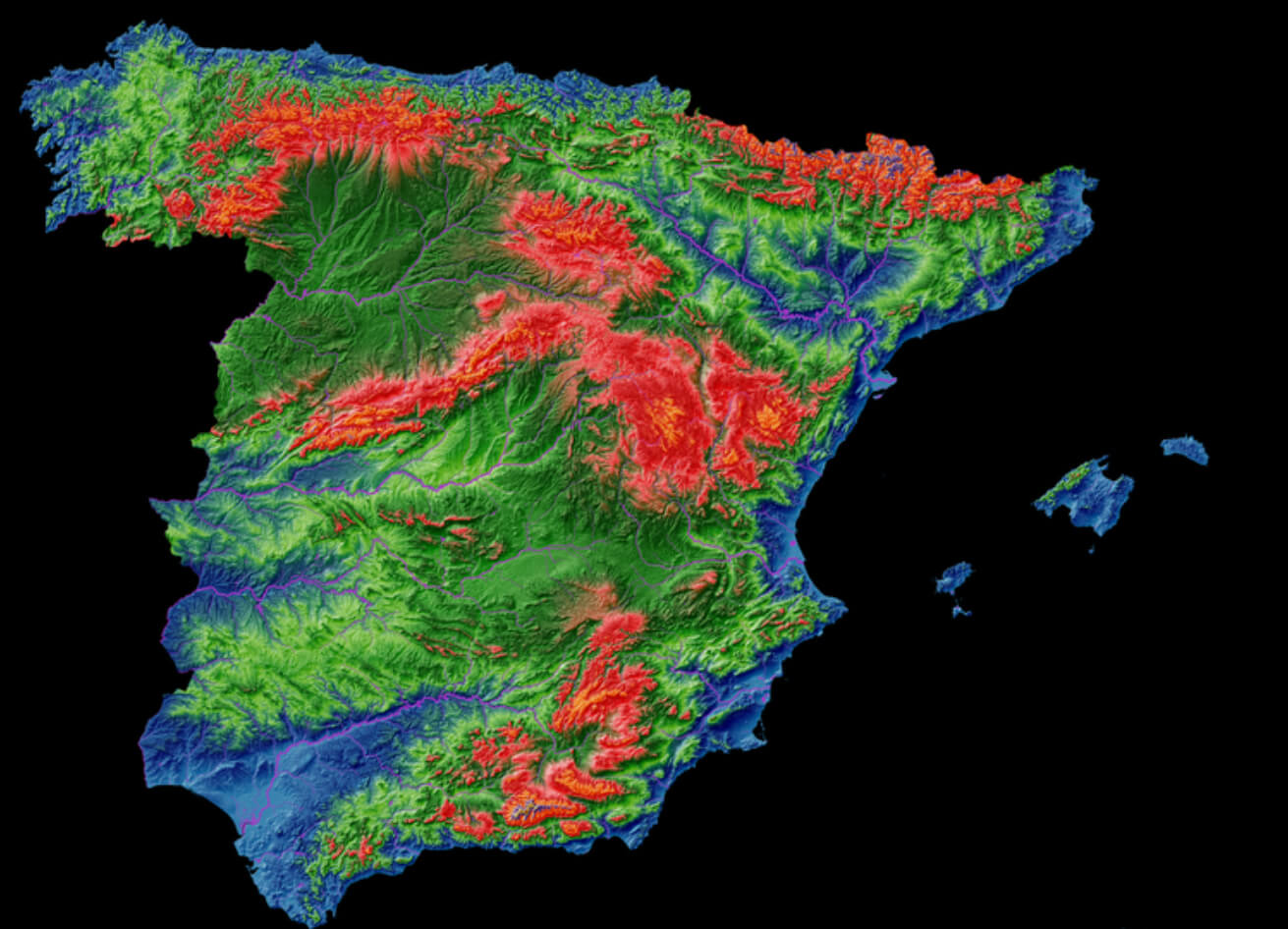
Elevation map of Spain showing mountain ranges and altitude variations.
This elevation map of Spain uses colour gradients to represent different altitudes, with red indicating higher elevations and blue indicating lower areas. The Pyrenees in the north-east and the Sierra Nevada in the south appear prominently in red, highlighting their significant altitude. The central meseta plateau, which covers much of inland Spain, is shown in shades of green, indicating moderate altitude. Coastal regions, particularly along the Mediterranean and Atlantic coasts, are shown in blue, reflecting the lowland areas. This map visually emphasises Spain’s mountainous terrain and the contrast between the highland interior and the lower coastal plains.
Spain’s economy is one of the largest in Europe, with tourism, agriculture, and industry as its key sectors. The country is one of the world’s top tourist destinations, known for attractions such as the Alhambra in Granada, the Sagrada Familia in Barcelona, and the Camino de Santiago pilgrimage route. Spain is also famous for its lively festivals, such as La Tomatina and the Running of the Bulls, and is a culinary hotspot, offering iconic dishes such as paella, tapas and churros. The country enjoys a Mediterranean climate over much of its territory, adding to its appeal as a sunny holiday destination.
Antique Map of Spain
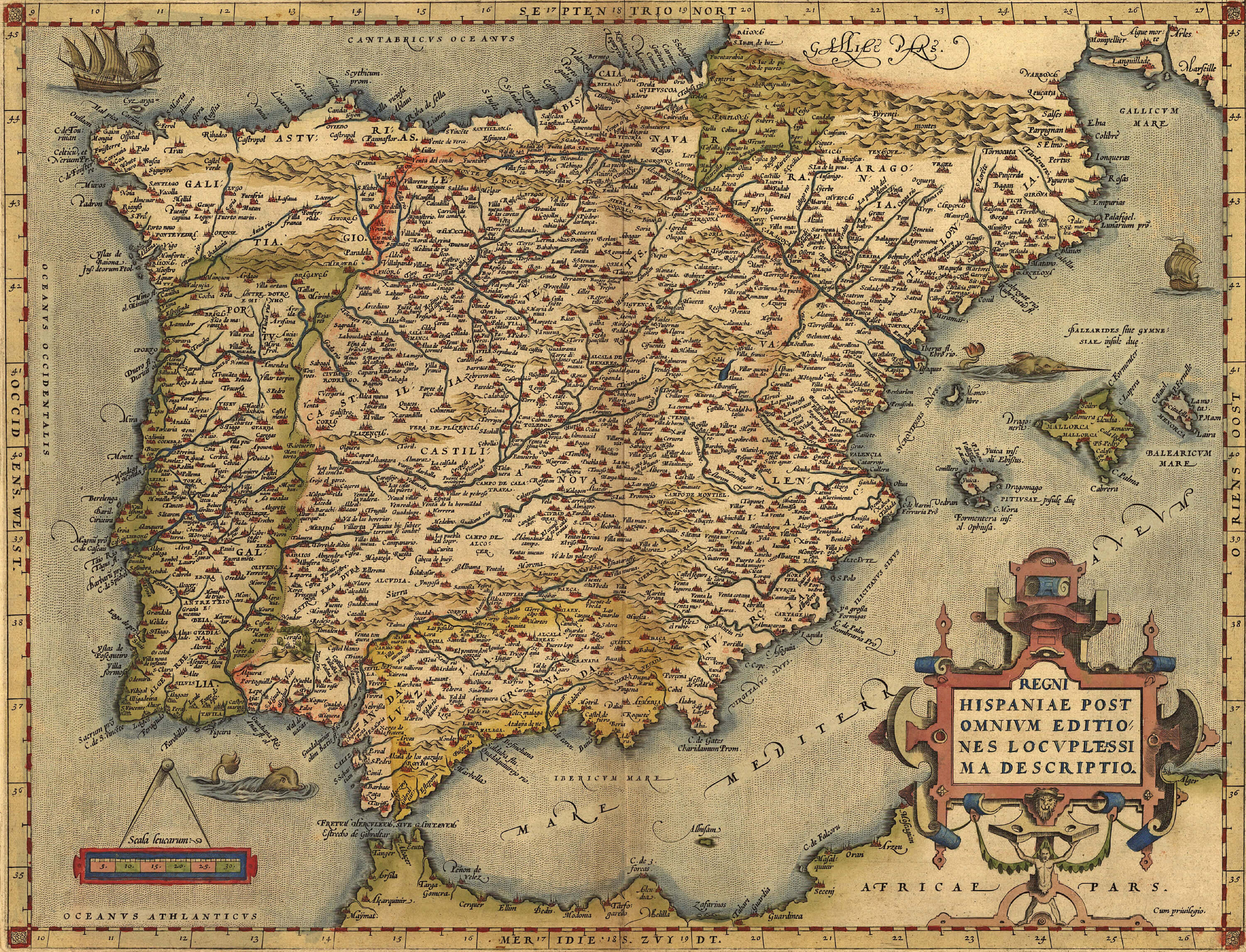
Antique Map of Spain, by Abraham Ortelius, circa 1570
Spain & Europe Satellite Image with Moonlight

Highly detailed Spain Europe Satellite Image, illuminated by moonlight. The glow of cities sheds light on the detailed exaggerated terrain and translucent water of the oceans.
Map of Spain with Islands
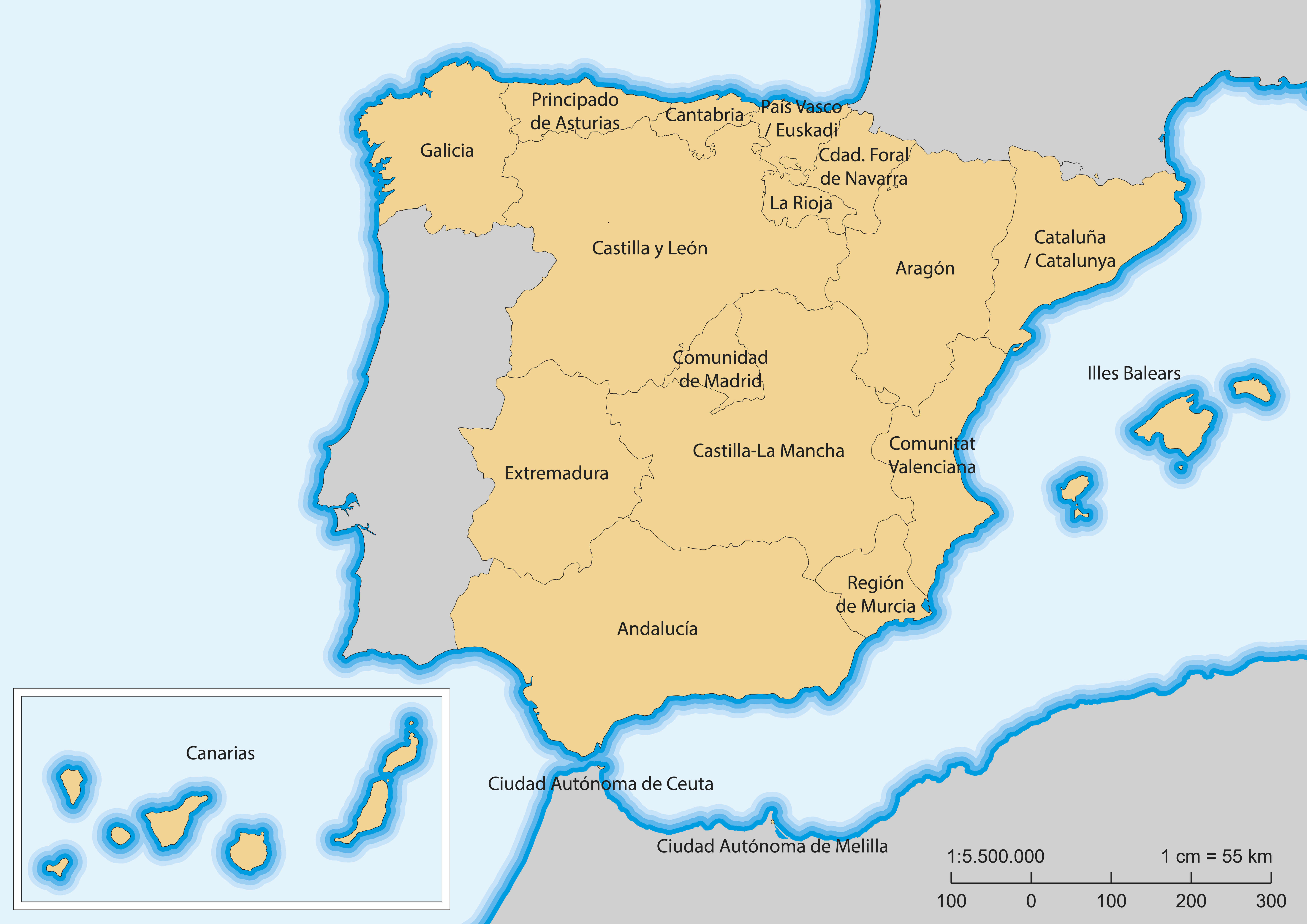
Map of Spain with islands and autonomous communities.
Spain Satellite Map and Mediterranean Sea

Highly detailed planet Earth. Exaggerated precise relief is illuminated by the rising sun from the east. Part of Europe, Spain, the Mediterranean Sea.
Spain Topographic Map
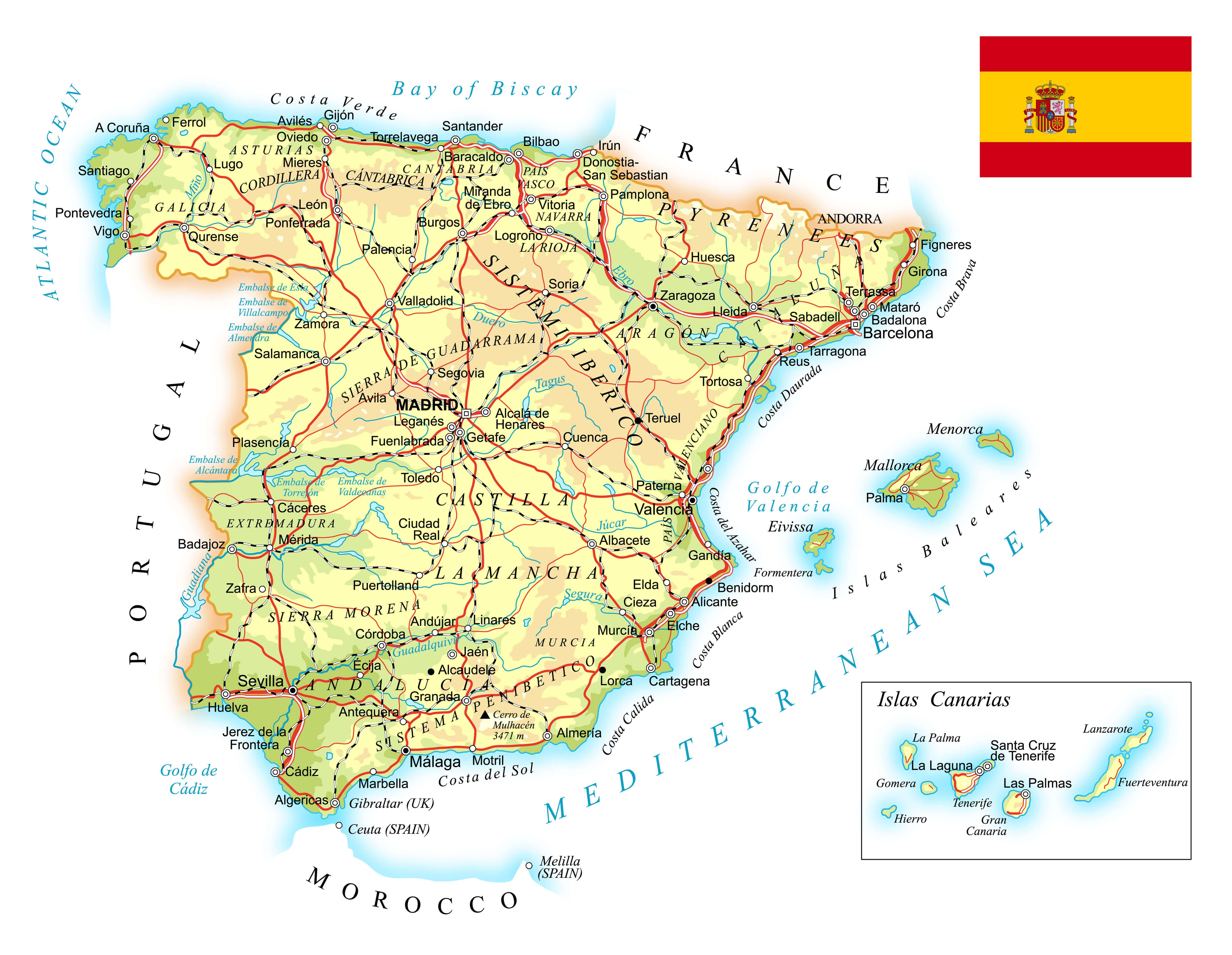
Spain detailed topographic map.
Spain Portugal Political Map 1894

Spain and Portugal political map. By Paul Vidal de Lablache, Atlas Classique, Librerie Colin, Paris, 1894 (first edition).
Spain Between 1808 and 1814 Old Map

Spain between 1808 and 1814 old map. By Paul Vidal de Lablache, Atlas Classique, Librerie Colin, Paris, 1894
Pushpin Marking on Spain Map
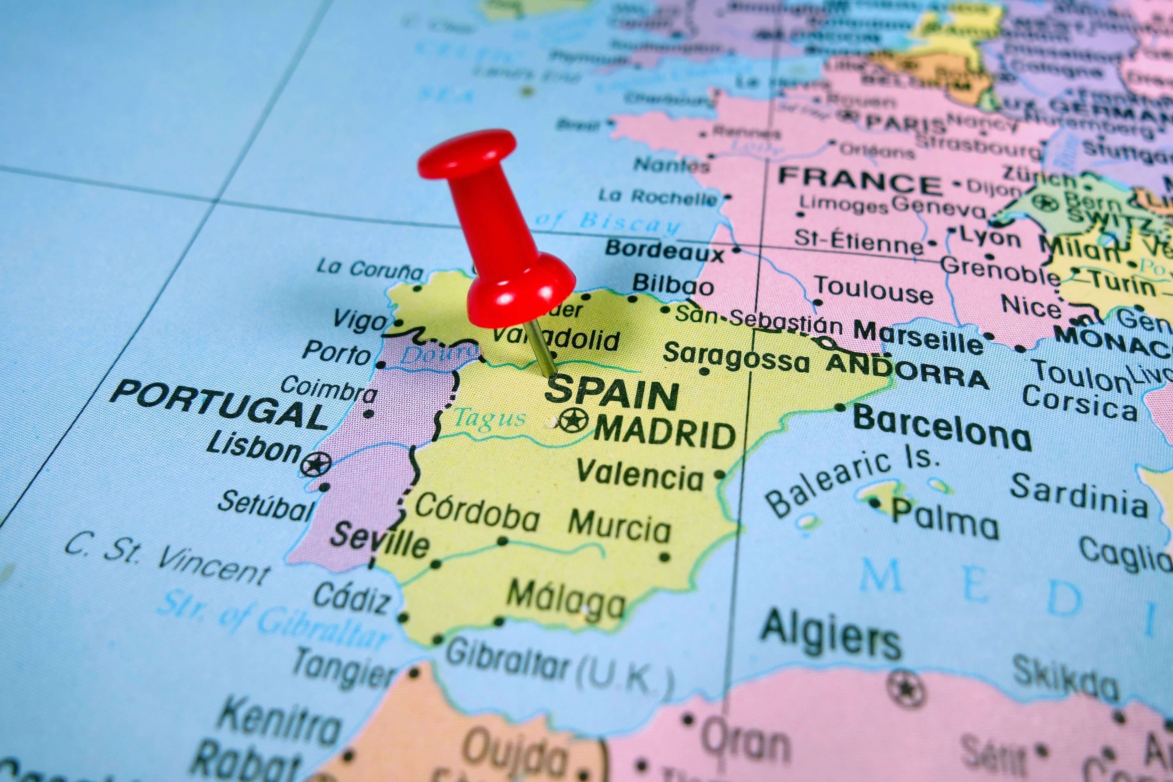
Pushpin marking on Spain map.
Map of Spain with Pushpin

Map of Spain with a blue pushpin stuck.
Map of Spain with Regions
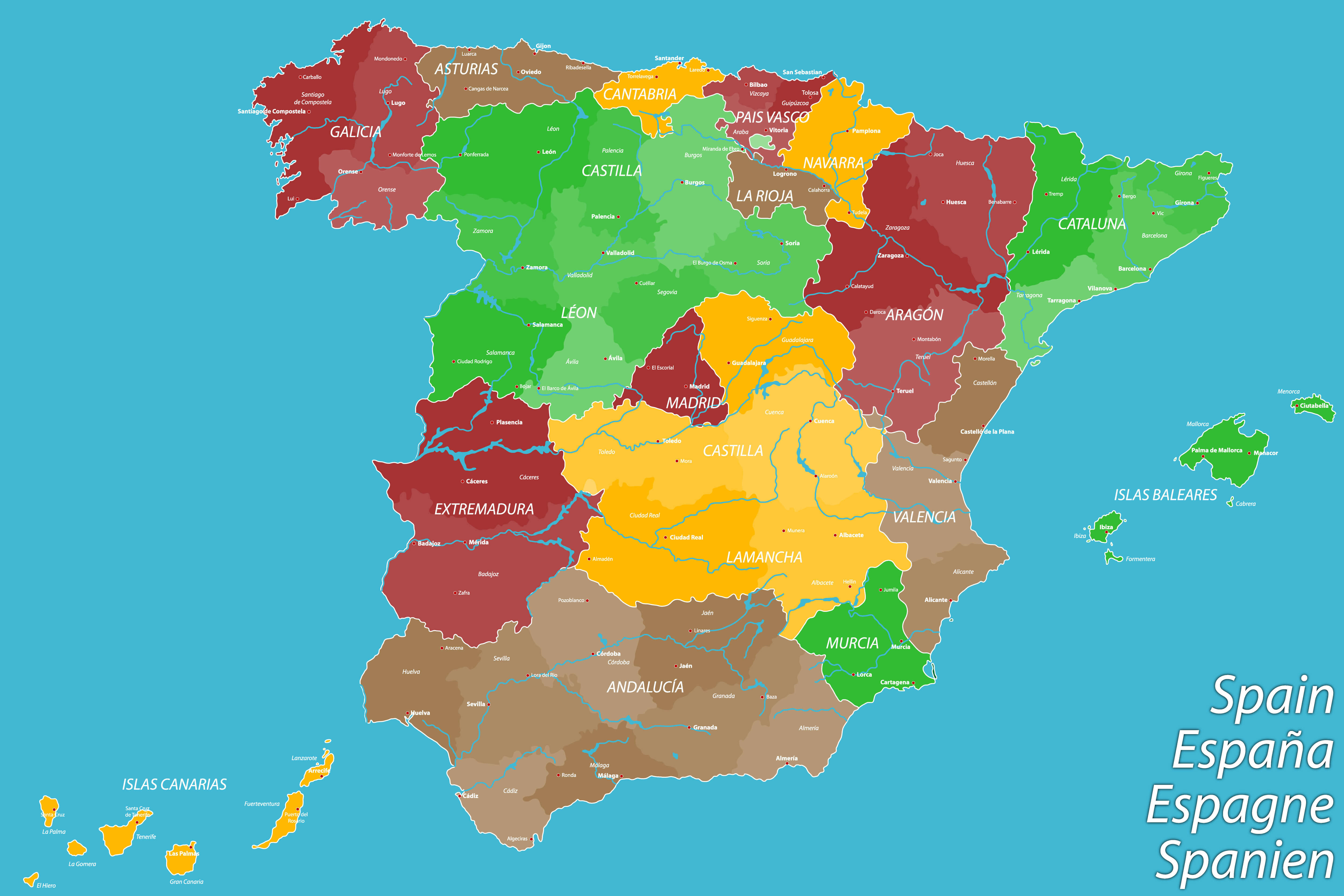
Map of Spain with Regions
Where is located Spain on the World Map
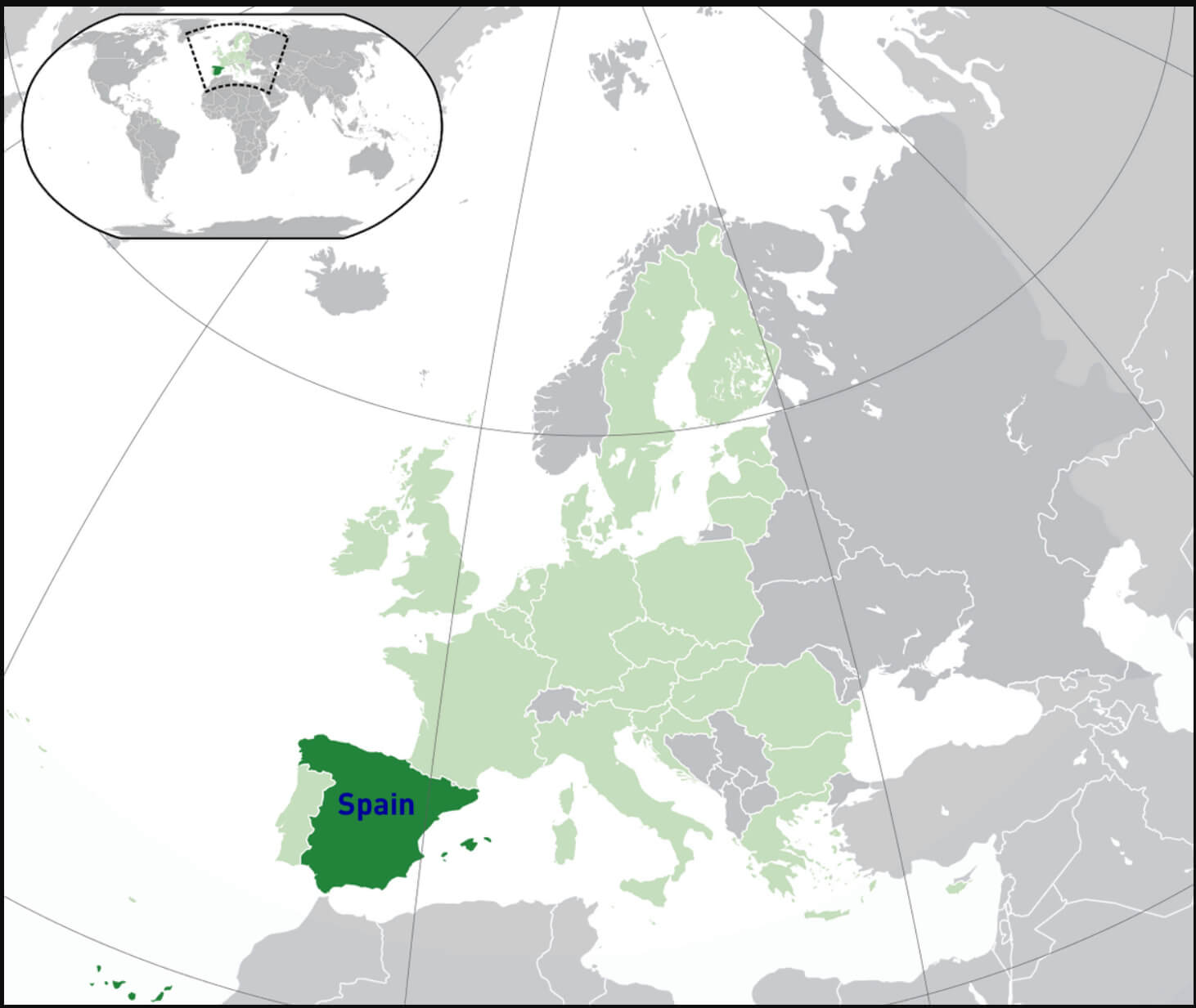
Spain is located in southwestern Europe on the Iberian Peninsula, which it shares with Portugal. Bordered by the Atlantic Ocean to the northwest, the Mediterranean Sea to the southeast, and the Bay of Biscay to the north, Spain’s strategic location between the Mediterranean and the Atlantic has made it a historic crossroads of civilisations. It borders Portugal to the west, France and the small principality of Andorra to the northeast, and the British territory of Gibraltar to the south. Spain also includes the Balearic Islands in the Mediterranean, the Canary Islands in the Atlantic Ocean off the northwest coast of Africa, and two autonomous cities, Ceuta and Melilla, on the north coast of Africa.
Spain’s geographical location provides a variety of climates and landscapes, ranging from the green mountainous regions of the north to the arid plains of the south. The country lies between 36° and 43° north latitude, with the majority of the country forming part of the Iberian Peninsula. Its strategic location on the Mediterranean and close to Africa has influenced Spain’s rich cultural heritage, as it has been a meeting point for European, Middle Eastern, and North African cultures for centuries.
Here are some statistical information about Spain:
Area: 505,990 km2 (195,360 sq mi)
Population: 48,797,875 (2024 estimate)
Capital and largest city: Madrid
Official languages: Spanish
Ethnic groups: 86.5% Spanish, 13.5% foreigners
Religion: 56.0% Roman Catholicism; (
37.5% non-practicing Catholic,
16.5% practicing Catholic), 14.9% atheist, 12.6% agnostic, 12.3% indifferent or no religion, 2.7% other religion, 1.5% unanswered
GDP (nominal): $1.731 trillion (2024 estimate)
Per capita: $35,788 (2024 estimate)
Currency: Euro (€) (EUR)
Calling code: +34
Time zone: UTC±0 to +1 (WET and CET)
Regions of Spain Map
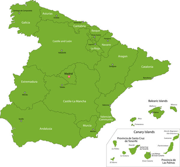
Green map of Spain’s regions, with Balearic and Canary Islands shown.
This green map of Spain highlights the various autonomous communities, showing the regional divisions within the country. Notable regions include Catalonia in the north-east, Andalusia in the south and the capital region of Madrid in the centre. The map also includes the Balearic Islands in the Mediterranean Sea and the Canary Islands off the northwest coast of Africa, both of which are part of Spain. Each region is labelled for easy identification, giving a clear overview of the geographical organisation of Spain.
Spain Administrative Map Overview
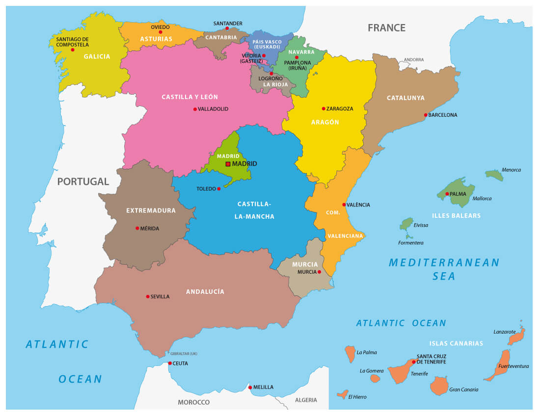
Administrative map of Spain with regions and major cities, including the Balearic and Canary Islands.
This administrative map of Spain shows the country’s autonomous communities and their main cities, including notable islands such as the Balearic Islands in the Mediterranean and the Canary Islands in the Atlantic. Each region is colour-coded for easy identification, highlighting Spain’s diverse political and geographical landscape. Key locations such as Madrid in the centre, Barcelona on the north-east coast in Catalonia and Valencia along the eastern coast are labelled. This map provides a visual breakdown of Spain’s structure, showing both continental and island territories.
Spain Administrative Map with Autonomous Regions
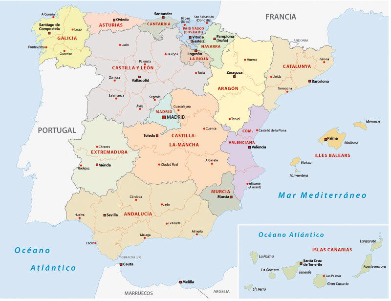
Spain Administrative Map with Autonomous Regions and Cities
This administrative map of Spain shows the country’s seventeen autonomous communities, each clearly coloured and labelled to show the diverse regions that make up the nation. The main autonomous communities, such as Catalonia, Andalusia and Madrid, are shown with their capitals. The Balearic and Canary Islands are also highlighted, emphasising Spain’s territorial reach beyond the mainland. This map provides a clear geographical representation of Spain’s administrative structure, including regions with distinct cultural and linguistic identities.
Spain Blank Map
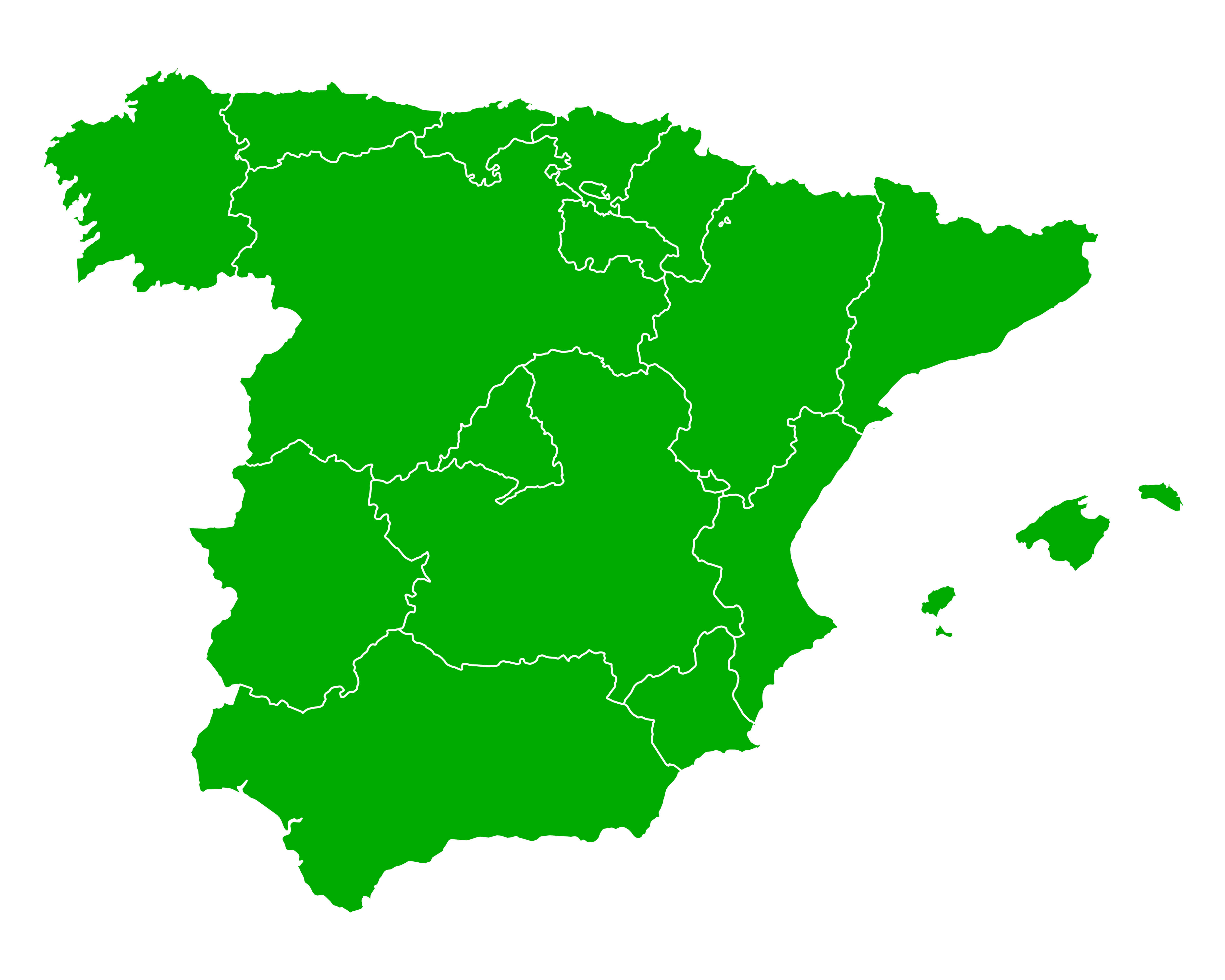
Spain blank map
Spain Blank Map with Provinces
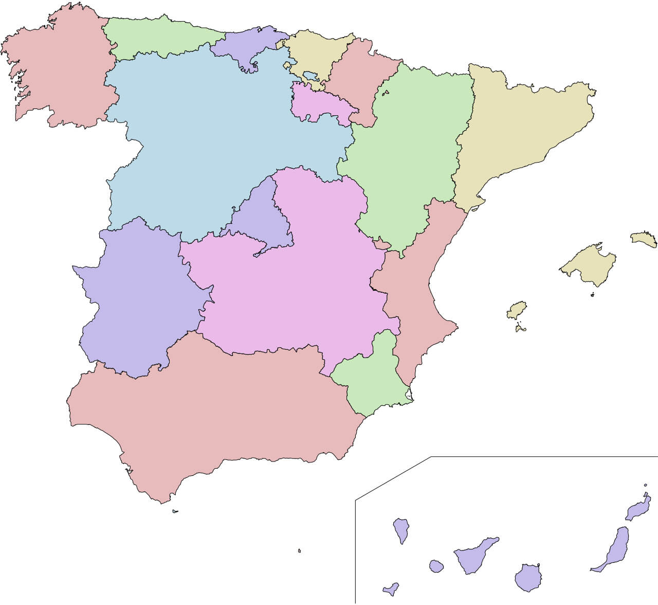
Spain blank map with provinces
Map of Major Cities in Spain
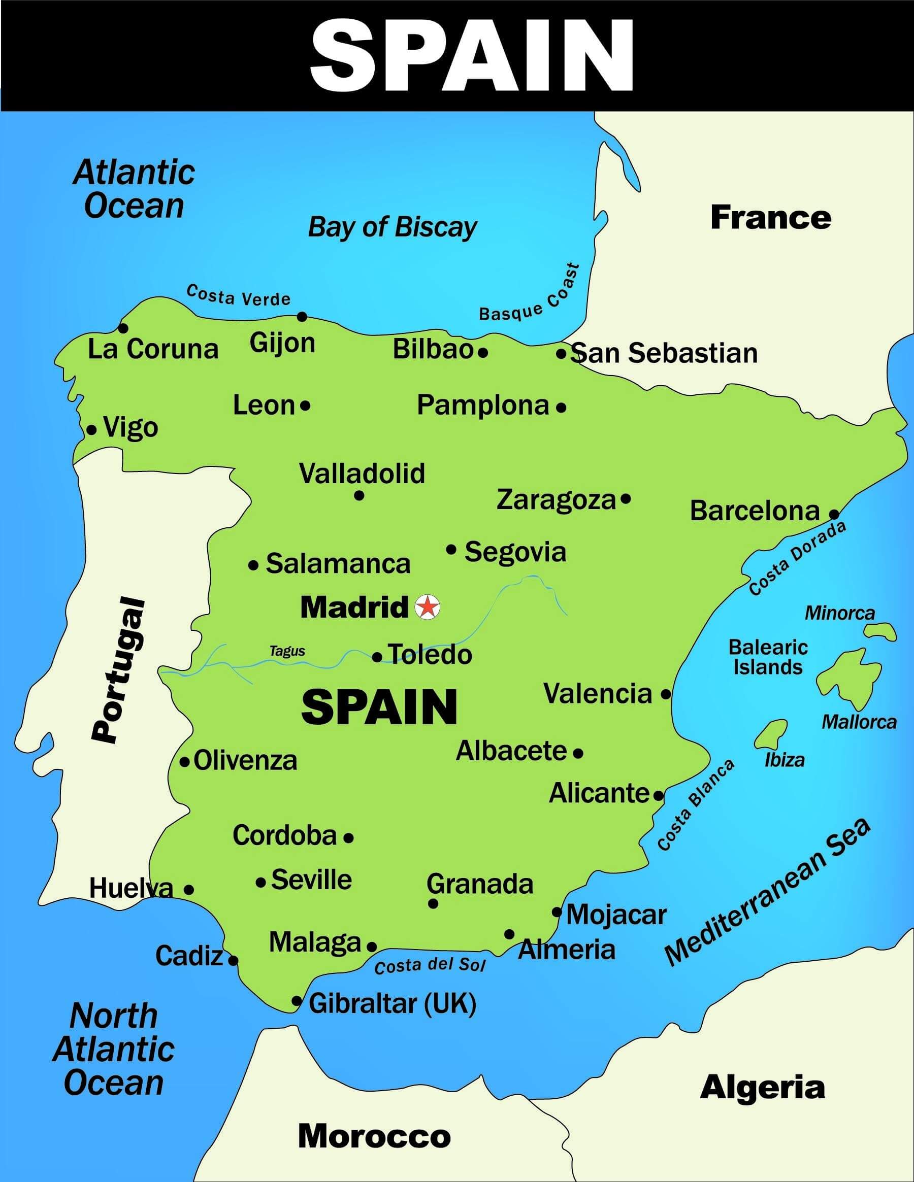
Map showing major cities and coastal regions of Spain.
This map of Spain highlights some of the country’s major cities and coastal regions, illustrating Spain’s geographical position on the Iberian Peninsula. Major cities such as Madrid, Barcelona and Valencia are prominently marked, along with notable coastal areas such as the Costa del Sol and Costa Blanca. The map also shows Spain’s proximity to neighbouring countries such as Portugal and France, as well as its location on the Atlantic Ocean and Mediterranean Sea, highlighting Spain’s strategic position for trade, tourism and cultural exchange within Europe.
Overview of Spain’s Köppen Climate Map
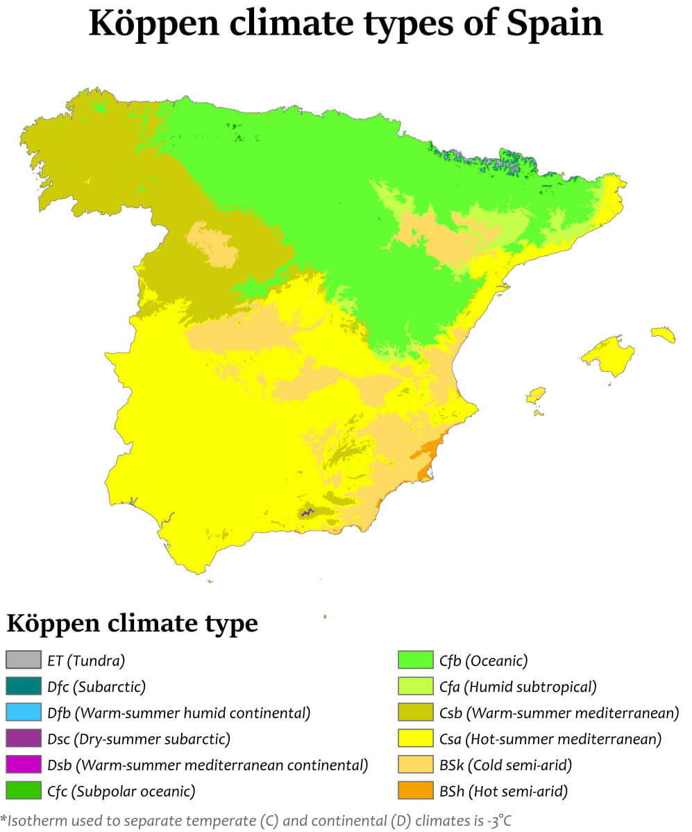
Map showing Köppen climate types across Spain’s regions map.
This map of Spain shows the Köppen climate classification across the country, showing the different climate zones due to the different topography and geography. In the north, an oceanic climate (Cfb) dominates, characterised by mild temperatures and constant rainfall. Inland, especially in the central and south-eastern regions, there is a hot summer Mediterranean climate (Csa), while a cold semi-arid climate (BSk) prevails in the drier inland areas. A warm summer Mediterranean climate (Csb) occurs in the north-west, especially near Galicia. The Balearic Islands and parts of the Mediterranean coast also reflect the hot summer Mediterranean climate, reinforcing the country’s climatic diversity from oceanic and Mediterranean to semi-arid.
Foreign Population Distribution in Spain (2005)
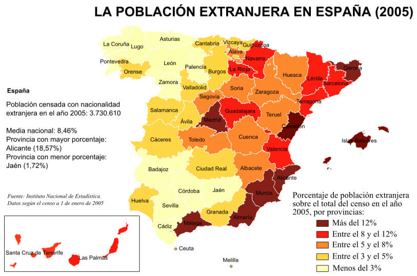
Map of Spain showing foreign population percentages by province in 2005.
This map shows the distribution of the foreign-born population in Spain by province in 2005. The national average for foreign residents is 8.46%, with the highest concentration in Alicante (18.57%) and the lowest in Jaén (1.72%). The coastal provinces, particularly in the east and south – such as Alicante, Malaga and the Balearic Islands – have higher percentages (over 12%) of foreign residents. This trend reflects the attractiveness of these regions for expatriates, especially along the Mediterranean coast. In contrast, the interior provinces have a lower percentage of foreign population, often below 5%, reflecting a more localised foreign presence in Spain’s metropolitan and coastal areas.
Linguistic Diversity Map in Spain
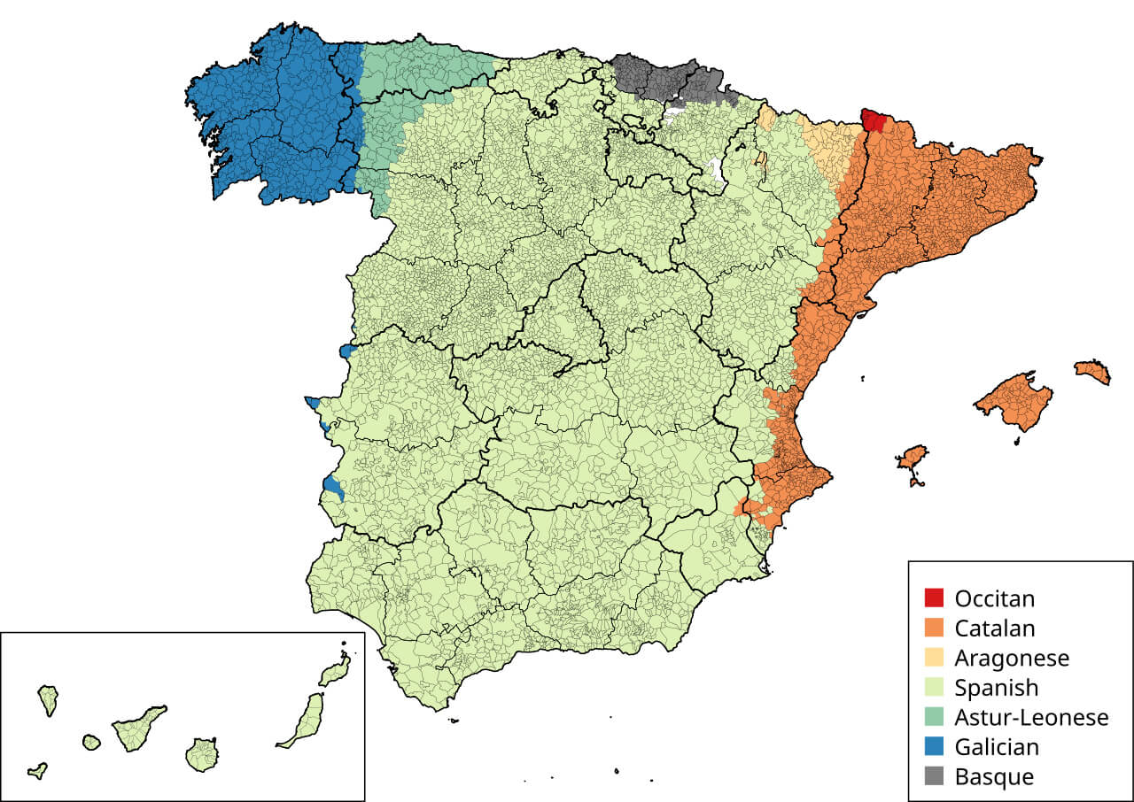
Map of Spain showing regions by predominant languages
This map shows the regional distribution of languages spoken in Spain. Spanish (Castilian) dominates most of the country, shown in light green. In the north-east, Catalan is widely spoken, especially in Catalonia and the Balearic Islands, shown in orange. Basque, shown in dark grey, is spoken mainly in the Basque Country and parts of Navarre. Galician, shown in blue, is predominant in Galicia in the north-west. Smaller regions in Aragon (light yellow) and the Val d’Aran (red) also have their own languages: Aragonese and Occitan respectively. This linguistic map reflects Spain’s rich cultural diversity, with each language rooted in different historical and regional identities.
Major Cities and Rivers of Spain

Spain map with major cities and rivers: Madrid, Barcelona, Ebro, Guadalquivir.
This map of Spain highlights its major cities and prominent rivers, illustrating the geographical distribution of urban centres and major waterways throughout the country. Madrid, the capital, is centrally located, while Barcelona, on the north-eastern Mediterranean coast, demonstrates Spain’s cultural and economic diversity. Major rivers such as the Ebro, which flows into the Mediterranean, the Guadalquivir in Andalusia and the Tagus, which passes through Toledo, are vital to agriculture and regional development. This map provides an insightful tool for understanding Spain’s urban and natural landscapes.
Major Cities and Rivers Highlights of Spain
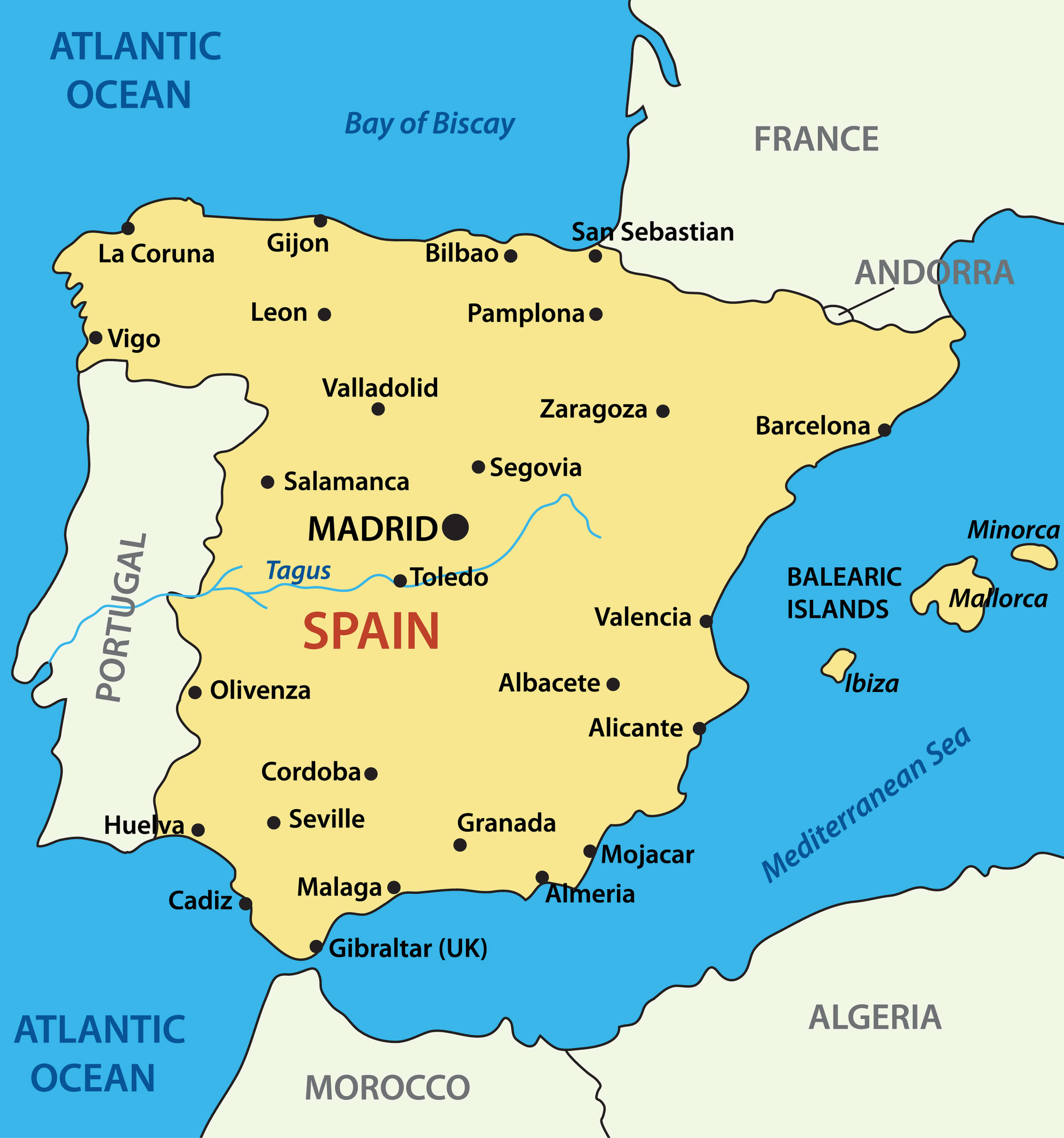
Map of Spain showing major cities, rivers, and surrounding regions
This map of Spain highlights major cities, rivers and neighbouring countries. Madrid, the capital and largest city, lies in the centre, with other major cities including Barcelona on the north-eastern Mediterranean coast and Seville and Malaga in the south. The map also includes notable cities along the Atlantic coast, such as La Coruña, Bilbao and Gijon, and cities close to Spain’s borders, including Zaragoza near France and Valencia on the eastern coast. Spain’s major rivers, such as the Tagus, are also shown, along with islands in the Balearic archipelago, such as Mallorca and Ibiza. Neighbouring countries such as Portugal, France, Andorra and Morocco (across the Strait of Gibraltar) are clearly shown, demonstrating Spain’s strategic position between the Mediterranean and the Atlantic.
Overview of Spain’s Regions and Major Transportation Routes
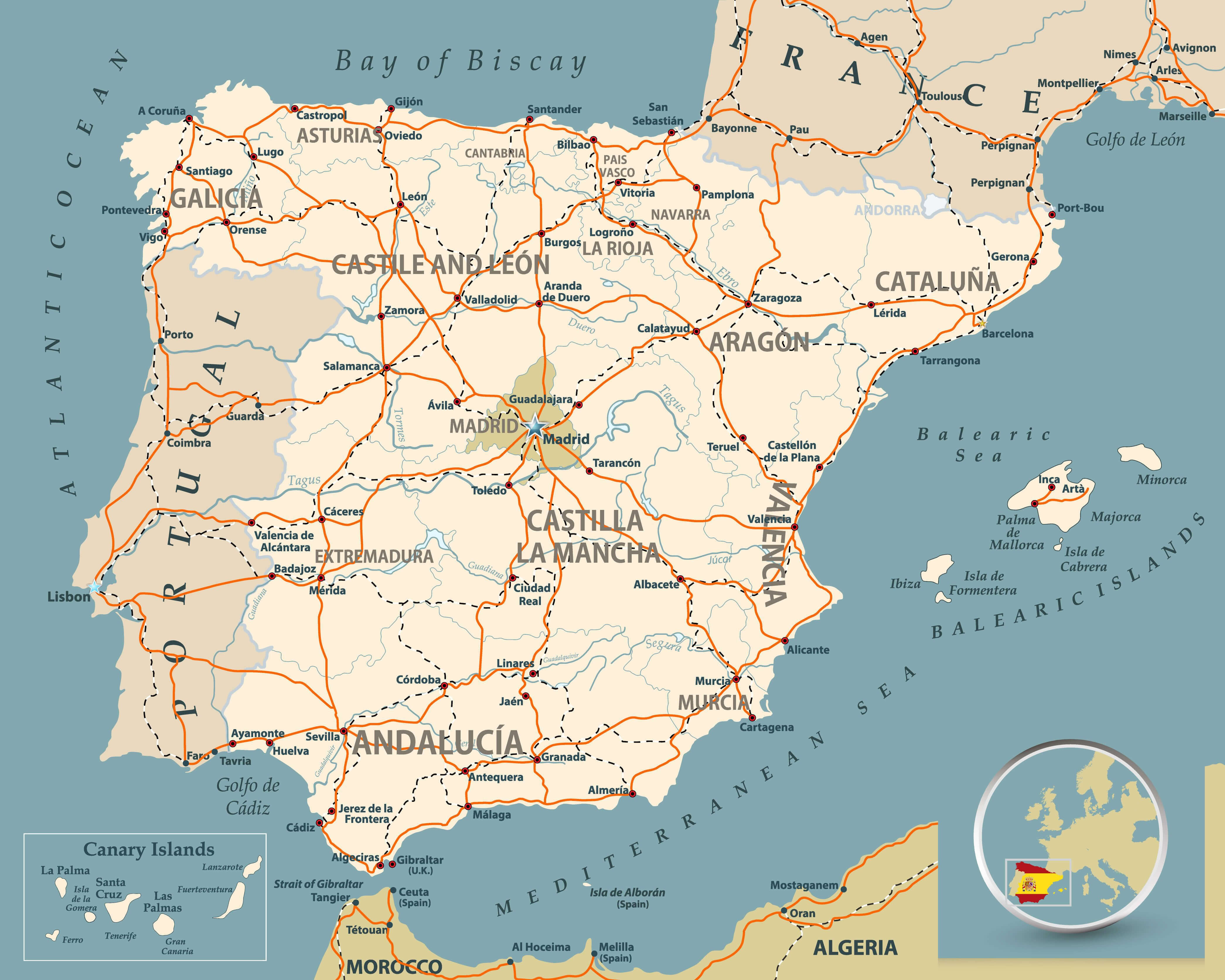
Map of Spain showing regions, major cities, and transport routes
This detailed map of Spain shows its autonomous communities, major cities and transport routes. Key regions such as Andalusia in the south, Catalonia in the north-east and Galicia in the north-west are labelled to emphasise the country’s administrative divisions. The map highlights the main motorways and railway lines linking major cities such as Madrid, Seville, Barcelona and Valencia, illustrating Spain’s well-integrated transport network. Surrounding features include the Bay of Biscay to the north, the Mediterranean Sea to the east and the neighbouring countries of France, Portugal and Morocco across the Strait of Gibraltar. The Canary Islands are shown in an inset, providing a comprehensive view of Spain’s geography and infrastructure.
Physical and Population Features of Spain
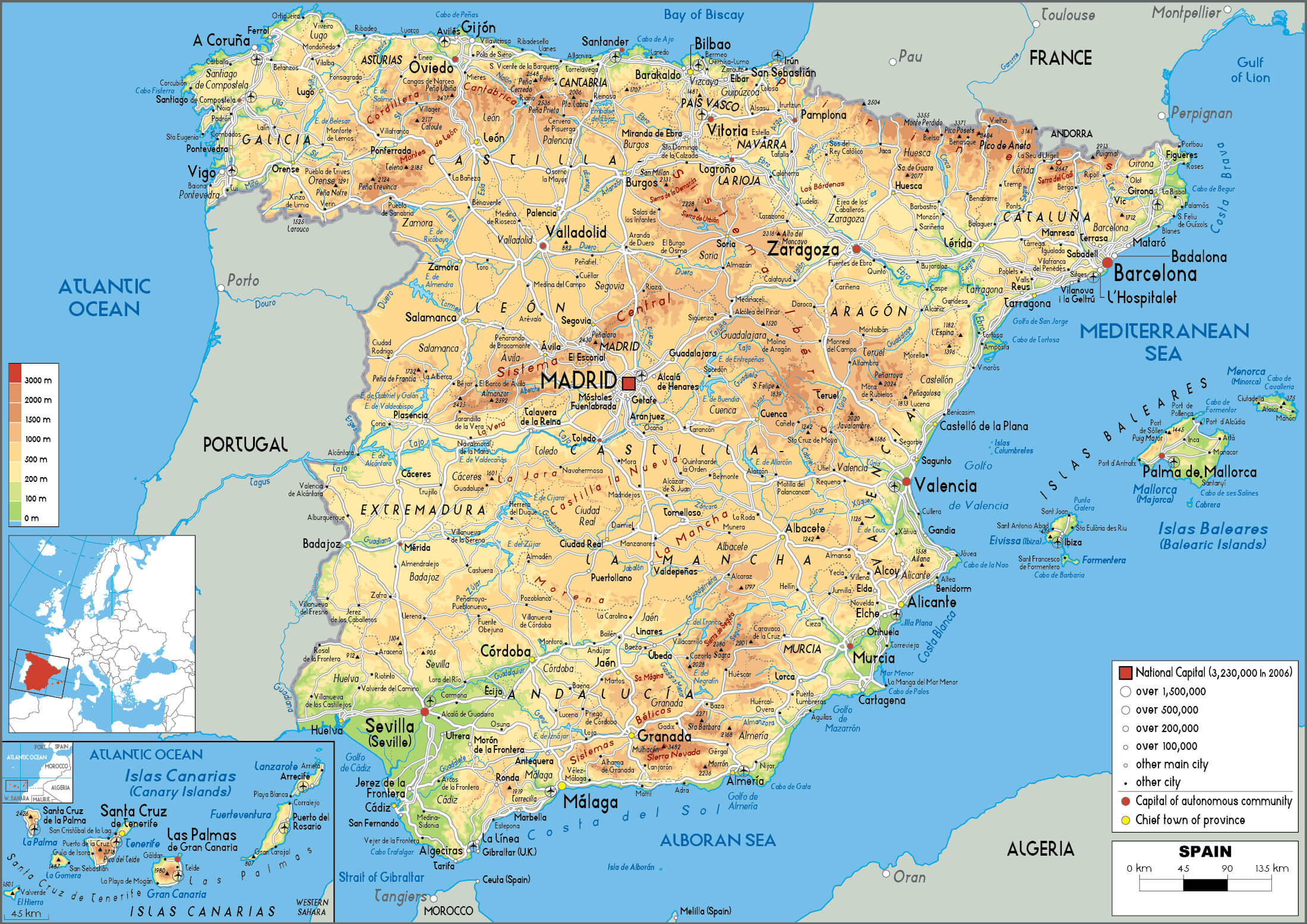
Physical map of Spain with major cities, mountains, and rivers.
This detailed physical map of Spain shows the country’s varied terrain, major cities and population centres. Mountain ranges such as the Pyrenees in the north-east and the Sierra Nevada in the south are clearly marked, showing the diversity of Spain’s landscapes. The map also illustrates Spain’s rivers, including the Ebro, Duero and Guadalquivir, as well as major motorways and railway lines connecting cities such as Madrid, Barcelona, Valencia and Seville. Population density is indicated by symbols for different city sizes, showing densely populated areas along the Mediterranean coast and in central Spain. Insets for the Canary and Balearic Islands provide a complete view of the Spanish territories.
Population Density Distribution in Spain
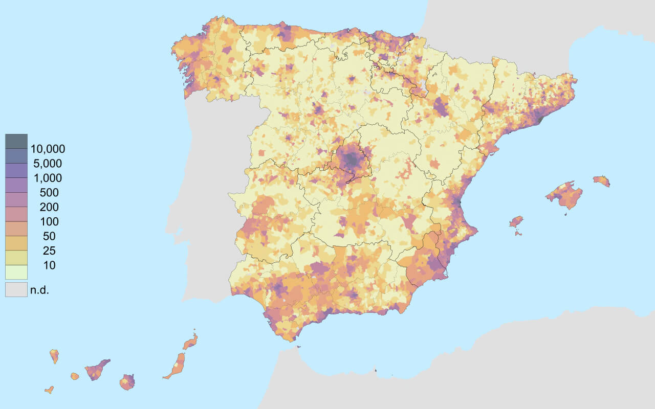
Map of Spain showing population density variations by region
This map illustrates Spain’s population density, with darker colours indicating higher population concentrations. Madrid, represented by the darkest shade, stands out as the most densely populated area in the centre of the country. Other dense population clusters can be seen along the Mediterranean coast, particularly in the regions around Barcelona and Valencia, and in the southern areas around Seville and Malaga. The north-western and central interior, as well as some parts of the west, are less densely populated and are shown in lighter shades. This pattern reflects urbanisation trends, with coastal and metropolitan areas attracting larger populations than the rural interior.
Regions of Spain and Key Cities
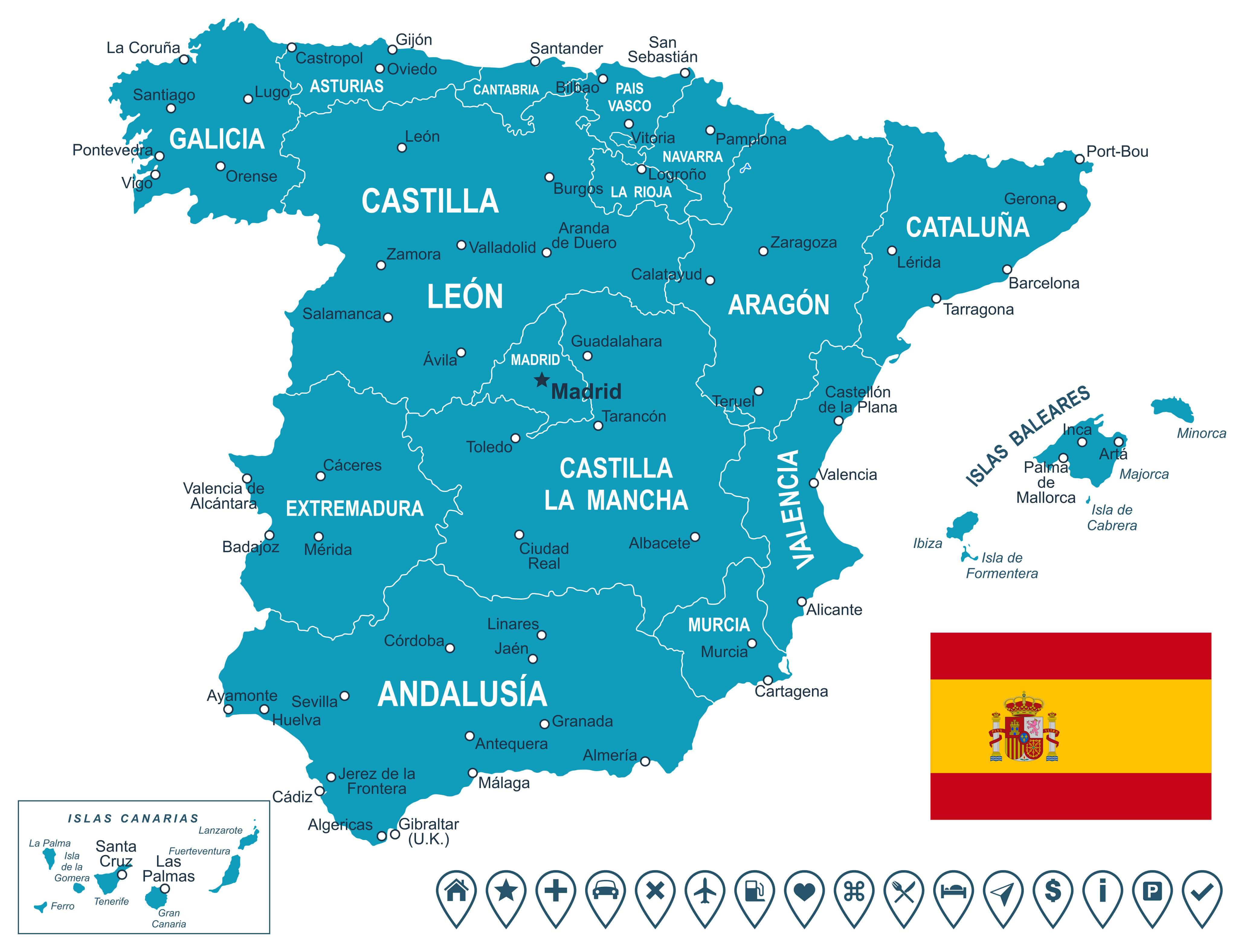
Map of Spain showing autonomous communities and major cities.
This map shows Spain’s autonomous communities, each labelled with its name and main cities. Regions such as Andalusia, Castile-La Mancha, Catalonia and Galicia are prominently marked, showing the administrative divisions of the country. Major cities such as Madrid, Barcelona, Valencia and Seville are identified as the main urban centres within these regions. The Canary and Balearic Islands are also shown in insets, illustrating Spain’s geographical reach beyond the mainland. The map includes icons representing various amenities or points of interest, highlighting Spain’s developed infrastructure and diverse regional identities.
Detailed Map of Spain’s Regions with Cities
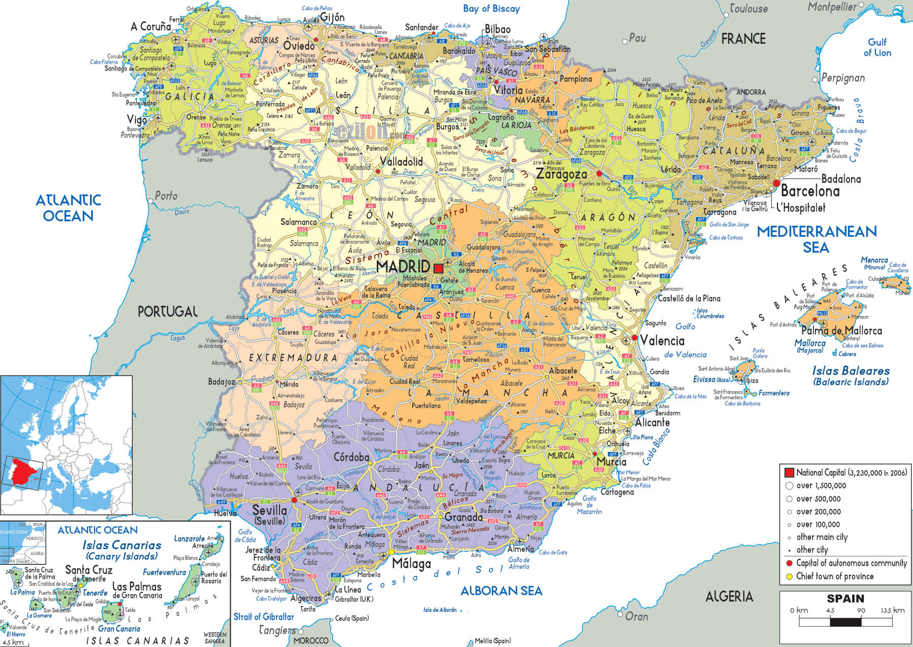
Map of Spain showing regions, major cities, and administrative capitals.
This map provides a comprehensive overview of Spain’s Autonomous Communities, highlighting major cities, provincial capitals and population densities in key urban areas. Regions such as Galicia, Catalonia, Andalusia and Castile-Leon are clearly marked with different colours to indicate administrative divisions. Major cities such as Madrid, Barcelona, Valencia and Seville are clearly labelled, as are smaller regional capitals such as Zaragoza, Valladolid and Málaga. Insets show the Canary and Balearic Islands, extending the map’s detail beyond the mainland. The legend shows the population size of cities, highlighting Spain’s urban centres and major provincial centres.
Major Rivers and Cities in Spain
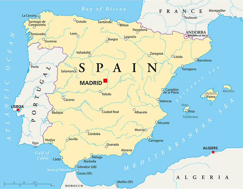
Map of Spain showing major cities and river systems across the country.
This map of Spain highlights major cities along the country’s major river systems. Central cities such as Madrid and Toledo are located near the Tagus, Spain’s longest river, which flows westwards into Portugal. Other major rivers, such as the Ebro in the north-east, the Guadalquivir in the south and the Duero in the north-west, are marked, providing an insight into the natural waterways that shape Spain’s geography. Major coastal cities such as Barcelona, Valencia and Málaga are shown along the Mediterranean Sea, while cities such as A Coruña and Bilbao are located along the northern coast on the Atlantic Ocean. The neighbouring countries of Portugal, France and Andorra are also visible, placing Spain in its European context.
Major Roads and Transportation in Spain
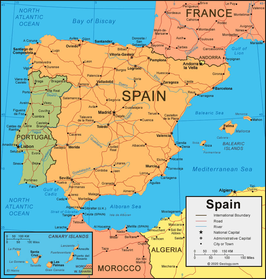
Map of Spain showing major roads, highways, cities, and neighboring countries.
This map of Spain highlights the country’s extensive road network, linking major cities and regions. Red lines indicate major motorways and roads, facilitating travel between central hubs such as Madrid, Barcelona, Valencia and Seville. Important international connections to neighbouring Portugal and France are also shown, indicating cross-border routes. The map includes Spain’s major rivers, such as the Tagus and Ebro, and insets show the locations of the Canary and Balearic Islands. Coastal cities are well connected to the Mediterranean Sea and the Atlantic Ocean, supporting trade and tourism. Spain’s capital, Madrid, and other administrative capitals are shown, providing a clear overview of the country’s infrastructure.
Topographic Features of Spain
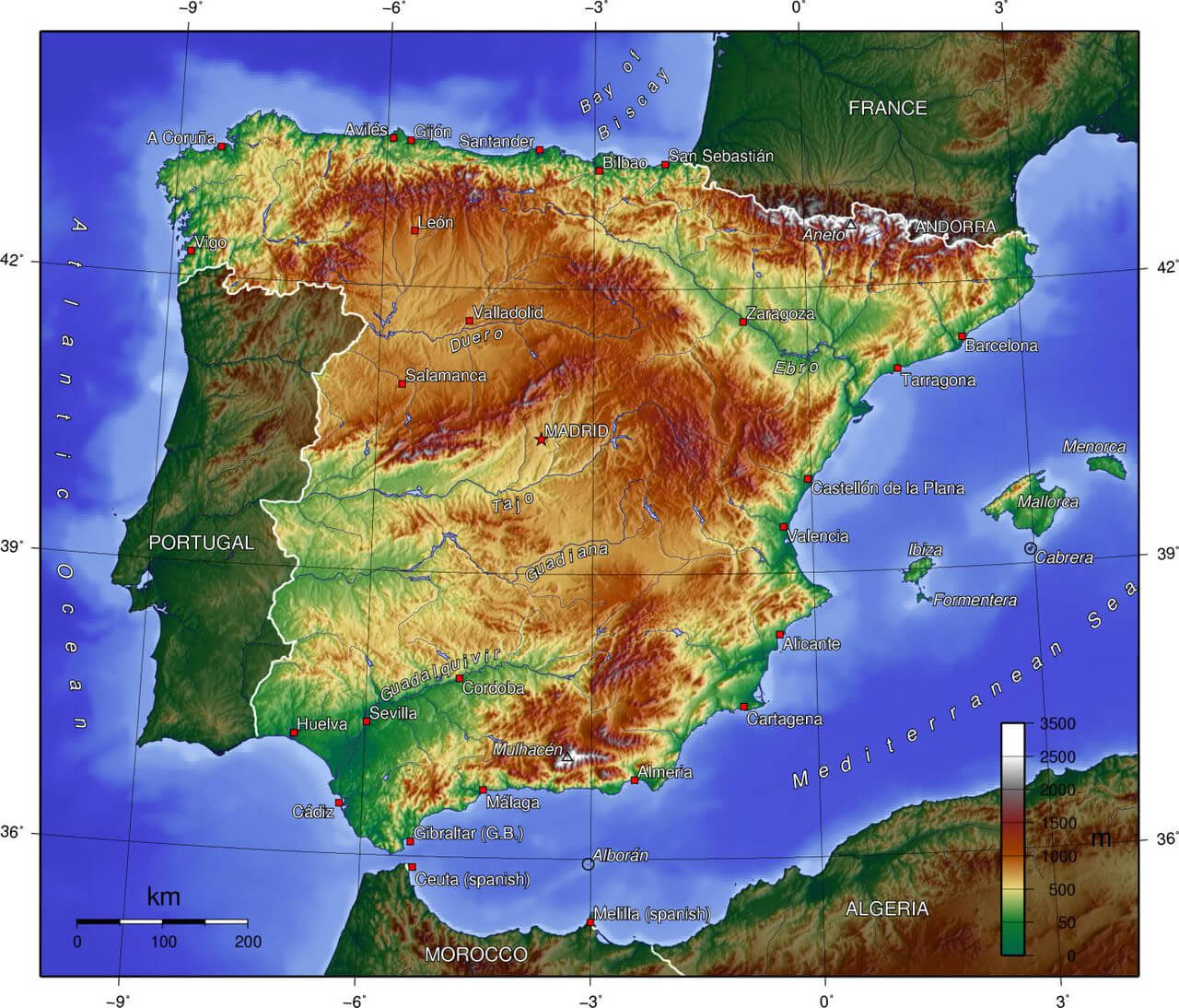
Topographic map of Spain showing elevations, mountains, and major rivers.
This topographical map of Spain highlights the country’s varied elevations and terrain. Mountain ranges such as the Pyrenees in the north-east, forming a natural border with France, and the Sierra Nevada in the south near Granada are clearly visible, with higher elevations marked in dark shades. The central Meseta plateau covers much of Spain’s interior and is of moderate elevation, falling gently to the coastal plains. Major rivers, including the Ebro, Tajo and Guadalquivir, cut through the valleys and provide vital waterways. Coastal regions are generally lower in elevation and support population centres such as Barcelona, Valencia and Málaga. Spain’s varying elevations create unique and varied landscapes, from high mountain peaks to vast plains and fertile valleys.
Spain’s Location on the World Map

Map showing Spain’s location in Europe and the world on a global scale.
This map illustrates Spain’s geographical position within Europe and its position in the world. Spain, highlighted in dark green, occupies the south-western part of Europe on the Iberian Peninsula, bordering Portugal to the west and France to the north-east. The map also shows Spain’s proximity to North Africa, separated by the Mediterranean Sea and the Strait of Gibraltar. The inset shows Spain’s position on a global scale, emphasising its role as a key European nation with easy access to both the Atlantic and the Mediterranean.
Where is Spain on the Europe Map?
Show Google map, satellite map, where is the country located.
Get directions by driving, walking, bicycling, public transportation and travel with street view.
Feel free to explore these pages as well:
- Map of Spain ↗️
- Valencia Map ↗️
- Murcia Map ↗️
- Exploring the Vibrant Corners of Cartagena, Spain ↗️
- Discovering Alicante: The Gem of Spain’s Costa Blanca ↗️
- A Collection of Spain Maps ↗️
- Discover Moorish Andalucia, Spain 1 ↗️
- Discover Moorish Andalucia, Spain 2 ↗️
- Gibraltar Map ↗️
- Italy Map ↗️
- France Map ↗️
- Europe Map ↗️
