
A collection maps of China; View a variety maps of China physical, political, relief map. Satellite image of China, higly detalied maps, blank map of China, World and Earth. And find more China’s country, regions, topography, cities, road, rivers, national, directions maps and atlas.

China Regions Map
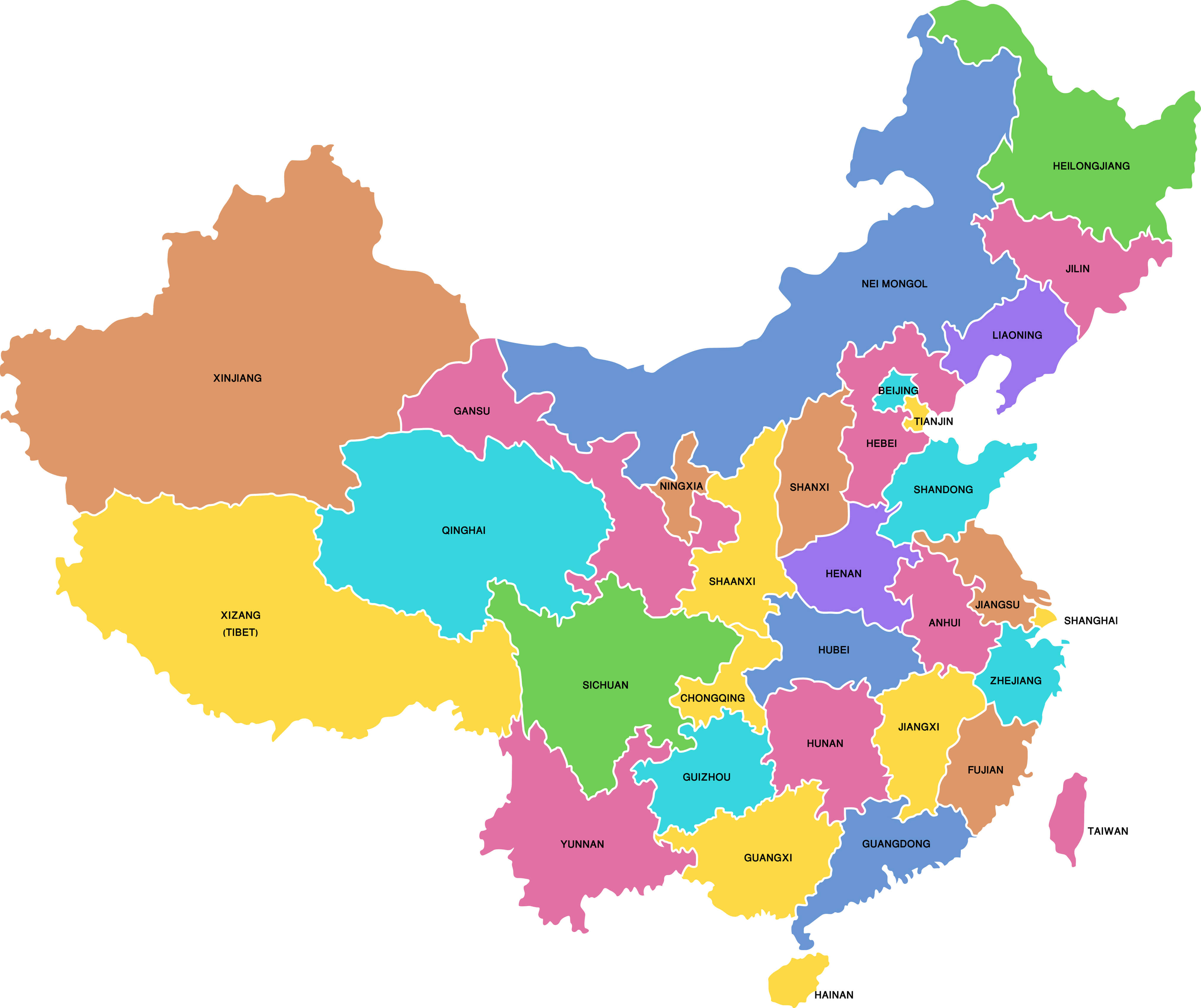 Highly detailed China map with all regions
This detailed China provinces map shows the country’s provincial-level administrative divisions, including provinces, autonomous regions and major municipalities such as Beijing, Shanghai, Chongqing and Tianjin, with clear boundaries and labels.
China National Map
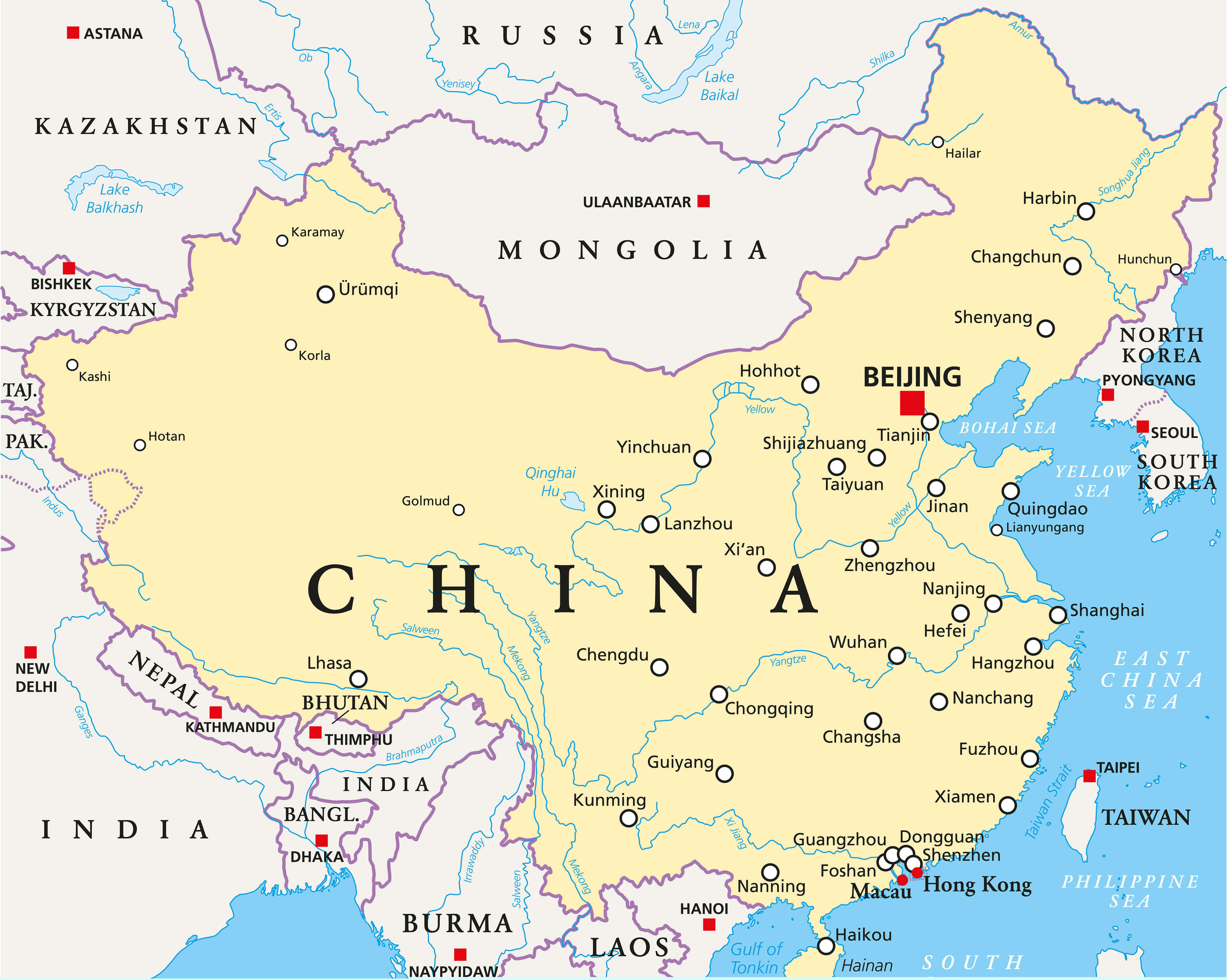 China political map with capital Beijing, national borders, important cities, rivers and lakes. English labeling and scaling.
This detailed political map of China shows Beijing, major cities such as Shanghai, Guangzhou and Chongqing, neighboring countries, international borders, major rivers, lakes, and surrounding seas, providing a clear geographic overview of China and East Asia.
China Regions and Major Cities Map
 A High Detail vector Map of the People’s Republic of China’s Regions and major cities.
Administrative Divisions Map of China

Administrative Divisions Map of China with provinces and major cities.
This detailed administrative map of China shows provinces, autonomous regions, municipalities, major cities, neighboring countries, national borders and surrounding seas, providing a clear geographic overview of China’s provincial-level divisions.
China Cities Map
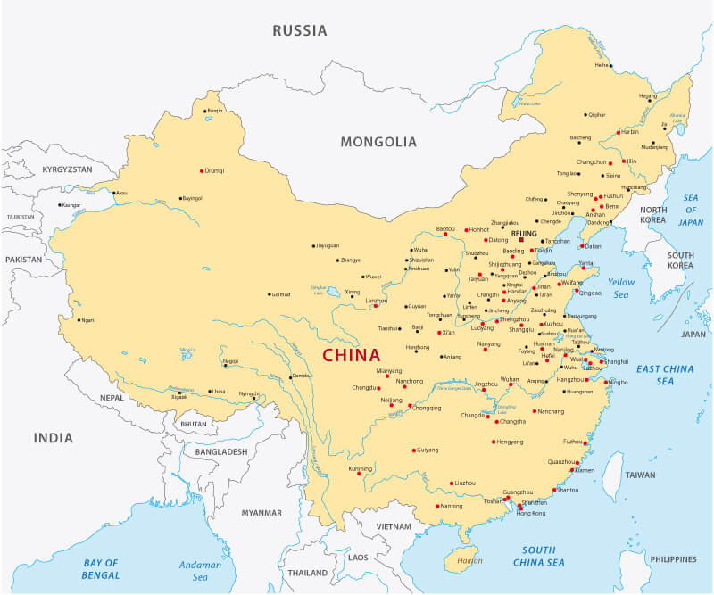
China Main Cities Map with rivers.
This detailed China cities map shows Beijing, Shanghai, Guangzhou, Shenzhen, Chongqing, Chengdu and other major cities, along with rivers, neighboring countries and surrounding seas, providing a clear geographic view of China’s urban centers.
China Blank Map

China Blank Map, administrative regional areas, Taiwan Map.
Provinces map of China

This detailed China provinces map shows provincial boundaries, autonomous regions, major cities including Beijing, Shanghai and Chongqing, highways, rivers and key geographic features, offering a clear overview of China’s administrative and transportation network.
China regions map with cities

China regions map

This detailed China regions map shows provinces, autonomous regions, major cities, neighboring countries and surrounding seas, highlighting Beijing, Shanghai, Guangdong, Sichuan, Xinjiang and Tibet for a clear view of China’s administrative geography.
China administrative map

China road map

Where is China in Asia map

China Key Facts
| Official Name | People’s Republic of China |
|---|---|
| Flag & Location |
 National flag of China  Location of China in East Asia |
| Geography | |
| Capital | Beijing Approximately 39.9° N, 116.4° E |
| Largest City | Shanghai — largest city by urban population |
| Region | East Asia |
| Total Area | 9,596,961 km² Approximately 3,705,407 sq mi |
| Water | Approximately 2.8% of total area |
| Land Borders | 14 countries One of the highest numbers of land borders of any country. |
| Population & Society | |
| Population | 1,404,890,000 2025 estimate; 2nd largest population in the world |
| Population Density | Approximately 146 people per km² |
| Official Language | Standard Chinese (Mandarin) |
| Writing System | Simplified Chinese in mainland China Traditional Chinese is widely used in Hong Kong and Macau. |
| Major Ethnic Groups |
Han Chinese: approximately 91.1% Other recognized ethnic groups: approximately 8.9% |
| Major Cities |
|
| Economy | |
| GDP (Nominal) | $20.852 trillion 2026 estimate — 2nd in the world |
| GDP per Capita | $14,874 Nominal, 2026 estimate |
| GDP (PPP) | $44.295 trillion 2026 estimate — 1st in the world |
| GDP per Capita (PPP) | $31,596 2026 estimate |
| Currency | Renminbi (yuan) — CNY |
| Gini Index | 36.0 2022 |
| Human Development Index | 0.797 — High 2023 HDI value |
| Codes & Communications | |
| Time Zone | China Standard Time (UTC+8) |
| Calling Code |
+86 — Mainland China +852 — Hong Kong +853 — Macau |
| ISO 3166 Code | CN |
| Internet TLD |
.cn — Mainland China .hk — Hong Kong .mo — Macau |
Geography of China
Where is China in World map

China is one of the world’s largest countries, covering approximately 9.6 million square kilometers across East Asia. Its geography is remarkably diverse, ranging from the high Tibetan Plateau and Himalayan mountains in the west to fertile river valleys, plains, deserts and an extensive Pacific coastline in the east. Major geographical features include the Yangtze River, Yellow River, Gobi Desert, Taklamakan Desert and the Tibetan Plateau. China shares land borders with 14 countries, making its location strategically important within Asia. The country’s enormous size and varied elevation create distinct climates, ecosystems and landscapes that can be explored through physical, political and regional maps of China.
Economy of China
China has one of the largest economies in the world and is a major center for manufacturing, international trade, technology and infrastructure development. Economic activity is particularly concentrated in large cities and coastal regions such as Shanghai, Beijing, Shenzhen and Guangzhou, while inland provinces have experienced significant development through transportation, industrial and urbanization projects. China is a leading producer and exporter of manufactured goods and has major industries in electronics, machinery, automobiles, renewable energy, construction and digital technology. Its vast domestic market, extensive transportation networks and connections with global supply chains give China an important role in both the Asian and global economy.
History of China
China

China has one of the world’s longest continuous recorded histories, spanning thousands of years and numerous dynasties, kingdoms and periods of political transformation. Early Chinese civilization developed around the Yellow River and Yangtze River regions, followed by influential dynasties including the Qin, Han, Tang, Song, Yuan, Ming and Qing. The Qin dynasty unified much of China in 221 BCE, while later dynasties expanded territory, trade and cultural influence. The imperial system ended in 1912 with the establishment of the Republic of China, and the People’s Republic of China was founded in 1949. China’s historical development has profoundly influenced its modern borders, cities, cultural regions and connections with neighboring parts of Asia.
Demographics of China
China cities map with rivers

China has a population of more than 1.4 billion people, making it one of the world’s most populous countries. Population distribution is highly uneven: the eastern and coastal regions contain many of China’s largest and most densely populated urban areas, while extensive parts of western China have much lower population densities. Major population centers include Shanghai, Beijing, Chongqing, Guangzhou and Shenzhen. China officially recognizes 56 ethnic groups, with Han Chinese forming the large majority of the population alongside numerous minority communities with distinct cultural traditions. Rapid urbanization and demographic changes, including population aging and low birth rates, are increasingly shaping China’s cities, workforce and long-term development.
Culture of China
Chinese culture has developed over thousands of years and encompasses a rich variety of traditions, philosophies, architecture, literature, art, cuisine, festivals and regional customs. Confucianism, Taoism and Buddhism have played important roles in shaping Chinese thought and cultural traditions, while landmarks such as the Great Wall, Forbidden City and classical gardens illustrate different periods of the country’s history. Cultural practices and cuisines vary considerably between regions, from Cantonese traditions in the south to Sichuan cuisine in the southwest and distinct customs across western and northern China. Celebrations such as the Lunar New Year and Mid-Autumn Festival remain culturally significant, while contemporary China combines these longstanding traditions with highly urbanized and technologically connected modern life.
China blank map

China flag map

China flag
China major cities map

China satellite image map

China vintage political map

Where is located China in the World map
Where is China on the Asia Map?
Show Google map, satellite map, where is the country located.
Get directions by driving, walking, bicycling, public transportation and travel with street view.
Feel free to explore these pages as well:
- China at a Glance: Facts, Geography, Cities, History, Economy & Culture ↗️
- China Map ↗️
- Map of China ↗️
- A Collection of China Maps ↗️
- China Cities Map ↗️
- Where is China on the Map ↗️
- China Physical Map ↗️
- China Political Map ↗️
- China Regions Map ↗️
- China’s Largest Cities ↗️
- China Time Zone Map ↗️
- Discover Time Zones of Asia with Russia, China, Australia, Pacific, and World ↗️
- The Heartbeat of China ↗️
- Unveiling the Mysteries of Chongqing ↗️
- Chengdu Unveiled ↗️
- Where is Taiwan in the World and A Collection of Taiwan Maps ↗️
- India Map ↗️
- Russia Map ↗️
- Pakistan Map ↗️
- Japan Map ↗️
- Asia Map ↗️
- Nepal Map ↗️

